

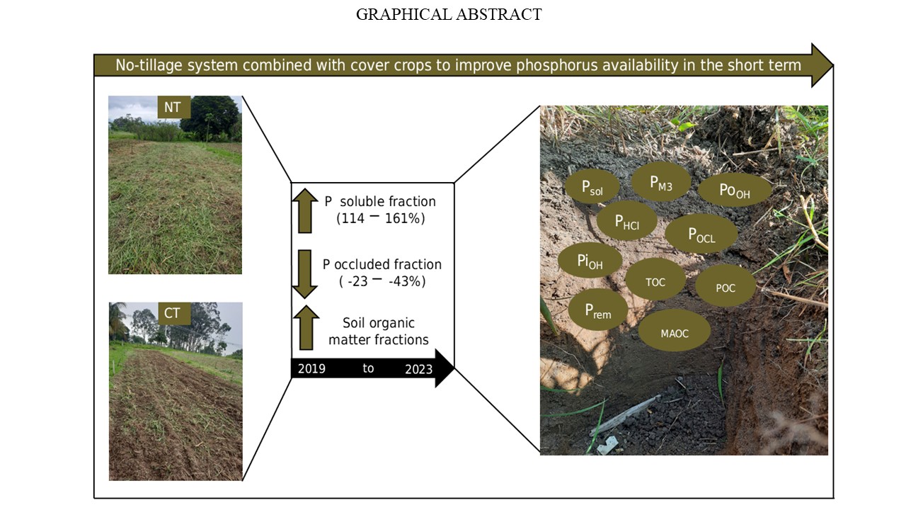
No-tillage system combined with cover crops to improve phosphorus availability in the short term
Thassiany de Castro Alves ![]() , Priscila Silva Matos
, Priscila Silva Matos ![]() , Luiz Alberto da Silva Rodrigues Pinto
, Luiz Alberto da Silva Rodrigues Pinto ![]() , Eduardo Albano Gomes de Abreu
, Eduardo Albano Gomes de Abreu ![]() , Mateus Belarmino da Silva
, Mateus Belarmino da Silva ![]() , Jhulia Kathelen Carvalho de Oliveira dos Santos
, Jhulia Kathelen Carvalho de Oliveira dos Santos ![]() , [...]
, [...]
30/Jun/2025
ABSTRACT Phosphorus (P) is an essential macronutrient for plant growth, and its availability is often influenced by management systems adopted over time. Adopting management systems, such as no-tillage, combined with cover crops, can influence soil P availability through factors including soil organic matter accumulation. This study aimed to evaluate how management systems and cover crops influence different P fractions and organic matter. Furthermore, the effect of the time since the implementation of management systems on phosphorus (P) availability and soil […]
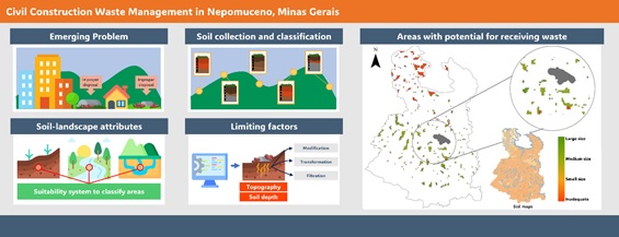
Disposal of solid waste from civil construction: a screening proposal for a suitability system and case study in Nepomuceno, Minas Gerais
Luana Sousa Costa ![]() , Marcelo Henrique Procópio Pelegrino
, Marcelo Henrique Procópio Pelegrino ![]() , Bruno Silva Villela
, Bruno Silva Villela ![]() , Maria Eduarda Carvalho Monteiro
, Maria Eduarda Carvalho Monteiro ![]() , Raísa Brito Vilela
, Raísa Brito Vilela ![]() , Daniela de Fátima Pedroso
, Daniela de Fátima Pedroso ![]() , [...]
, [...]
11/Mar/2024
ABSTRACT Most Brazilian municipalities do not have regulated areas for solid waste disposal in civil construction. Usually, residues are disposed of vacant lots and dumps, posing risks to the population health and the environment. Soils are the primary means for the disposal or recycling of waste, highlighting the importance of well-characterized soils and their respective landscape. This study aimed to establish a land suitability system for solid residues in civil construction and apply such information in a case study in […]
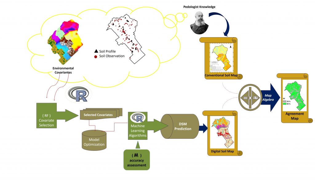
Digital Soil Mapping Using Machine Learning Algorithms in a Tropical Mountainous Area
02/Nov/2018
ABSTRACT: Increasingly, applications of machine learning techniques for digital soil mapping (DSM) are being used for different soil mapping purposes. Considering the variety of models available, it is important to know their performance in relation to soil data and environmental variables involved in soil mapping. This paper investigated the performance of eight machine learning algorithms for soil mapping in a tropical mountainous area of an official rural settlement in the Zona da Mata region in Brazil. Morphometric maps generated from […]
Plant-available soil water capacity: estimation methods and implications
01/Apr/2014
The plant-available water capacity of the soil is defined as the water content between field capacity and wilting point, and has wide practical application in planning the land use. In a representative profile of the Cerrado Oxisol, methods for estimating the wilting point were studied and compared, using a WP4-T psychrometer and Richards chamber for undisturbed and disturbed samples. In addition, the field capacity was estimated by the water content at 6, 10, 33 kPa and by the inflection point […]
Soil spatial variation and properties as related to Management units in an experimental area of integrated coconut production
01/Dec/2008
The objective of this work was to access spatial variations of soils from experimental plots for integrated coconut production based on the detailed mapping of soils and the construction of contour maps of soil properties. Observations and measurements were formed and samples collected in small trenches and soil profiles. The amount of soil clay from small trenches was evaluated in the field by finger touch feeling. Physical and chemical analyses were performed in all samples. Particle-size-distribution (profiles), Al, Ca and […]
Application of a comparative index in evaluation of land degradation risk
01/Dec/1998
The determination of land degradation risk in a watershed is an important factor in environmental and agricultural land-use planning. The current trend is to analyze the necessary information for land evaluation in a less subjective way and compatible with geoprocessing techniques. However, criteria and parameters used to quantitatively evaluate the land degradation risk at the watershed scale and based on Geographic Information Systems (GIS) still need to be better defined. The objective of this study, conducted in the second semester […]
Definition of tolerable soil erosion values
01/Sep/1997
Although the criteria for defining erosion tolerance are well established, the limits generally used are not consistent with natural, economical and technological conditions. Rates greater than soil formation can be accepted only until a minimum of soil depth is reached, provided that they are not associated with environmental hazard or productivity losses. A sequence of equations is presented to calculate erosion tolerance rates through time. The selection of equation parameters permits the definition of erosion tolerance rates in agreement with […]