

Hydropedological digital mapping: machine learning applied to spectral VIS-IR and radiometric data dimensionality reduction
Priscilla Azevedo dos Santos ![]() , Helena Saraiva Koenow Pinheiro
, Helena Saraiva Koenow Pinheiro ![]() , Waldir de Carvalho Carvalho
, Waldir de Carvalho Carvalho ![]() , Igor Leite da Silva
, Igor Leite da Silva ![]() , Nilson Rendeiro Pereira
, Nilson Rendeiro Pereira ![]() , Silvio Barge Bhering
, Silvio Barge Bhering ![]() , [...]
, [...]
03/Oct/2023
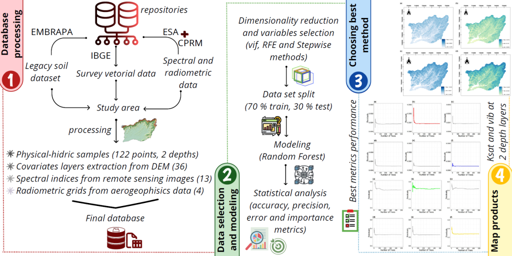
ABSTRACT Pedosphere-hydrosphere interface accounts for the association between soil hydrology and landscape, represented by topographic and Remote Sensing data support and integration. This study aimed to analyze different statistical radiometric and spectral data selection methods and dimensionality reduce environment-related data to support the classification of soil physical-hydric properties, such as soil basic infiltration rate (bir) and saturated hydraulic conductivity (Ksat); as well as to act in data mining processes applied to hydropedological properties digital mapping. Accordingly, research integrated information from […]
Digital soil mapping for the Parnaíba River delta, Brazilian semiarid region
João Victor Alves Amorim ![]() , Gustavo Souza Valladares
, Gustavo Souza Valladares ![]() , Marcos Gervasio Pereira
, Marcos Gervasio Pereira ![]() , Mirya Grazielle Torres Portela
, Mirya Grazielle Torres Portela ![]() , Andréa Maciel Lima
, Andréa Maciel Lima ![]()
04/Apr/2023
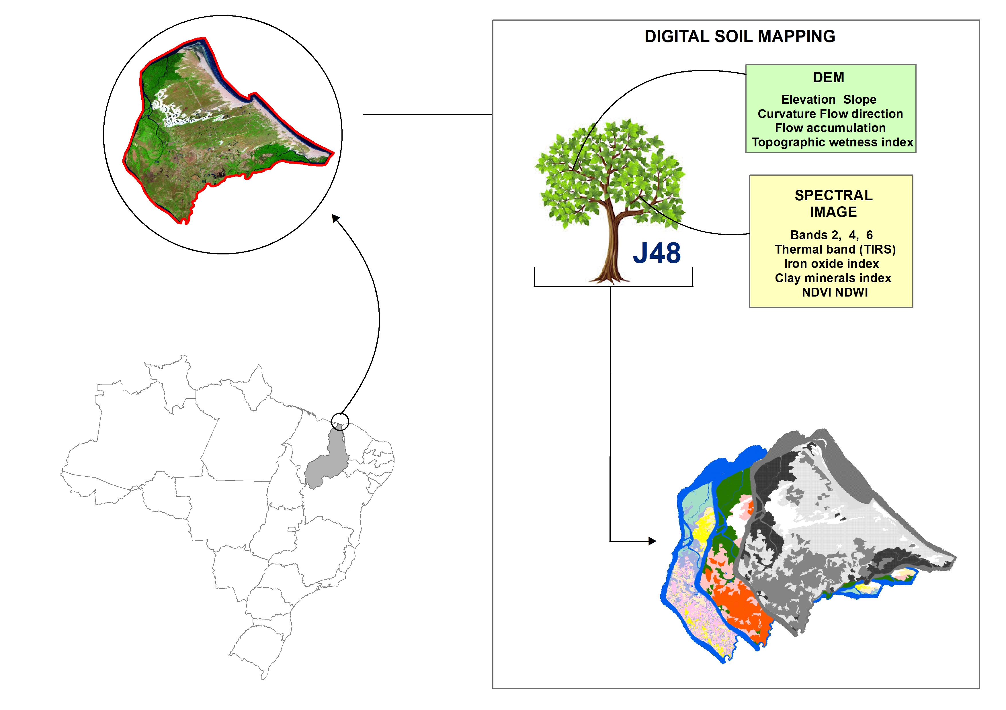
ABSTRACT Soil mapping is a permanent demand, but the traditional method does not allow fast execution and low cost. Digital soil mapping (DSM) aims to improve the process by working with models that treat soil spatial variability quantitatively. In this perspective, the objective of the study is to perform DSM of the Parnaíba River Delta, Northeastern Brazil, through the decision tree (DT) integration technique using a set of attributes derived from the digital elevation model (DEM) and satellite images as […]
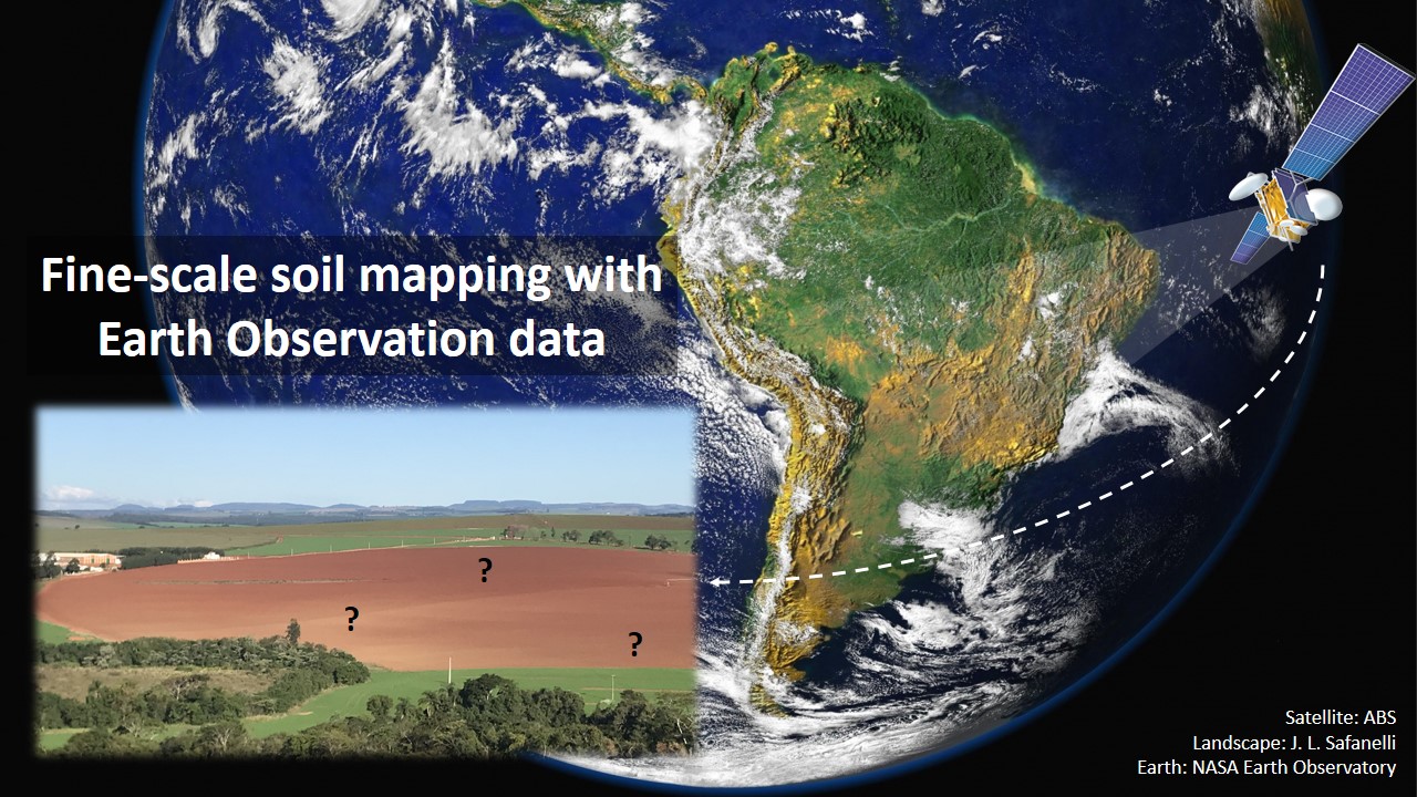
Fine-scale soil mapping with Earth Observation data: a multiple geographic level comparison
José Lucas Safanelli ![]() , José Alexandre Melo Demattê
, José Alexandre Melo Demattê ![]() , Natasha Valadares dos Santos
, Natasha Valadares dos Santos ![]() , Jorge Tadeu Fim Rosas
, Jorge Tadeu Fim Rosas ![]() , Nélida Elizabet Quiñonez Silvero
, Nélida Elizabet Quiñonez Silvero ![]() , Benito Roberto Bonfatti
, Benito Roberto Bonfatti ![]() , [...]
, [...]
24/Nov/2021
ABSTRACT Multitemporal collections of satellite images and their products have recently been explored in digital soil mapping. This study aimed to produce a bare soil image (BSI) for the São Paulo State (Brazil) to perform a pedometric analysis for different geographical levels. First, we assessed the potential of the BSI for predicting the surface (0.00-0.20 m) and subsurface (0.80-1.00 m) clay, iron oxides (Fe 2 O 3 ), aluminum (m%) and bases saturation (V%) contents at the state level, which […]
Satellite Spectral Data on the Quantification of Soil Particle Size from Different Geographic Regions
12/Sep/2018
ABSTRACT: The study of soils, including their physical and chemical properties, is essential for agricultural management. Soil quality must be maintained to ensure sustainable production of food and conservation of natural resources. In this context, soil mapping is important to provide spatial information, which can be performed using remote sensing (RS) techniques. Modeling through use of satellite data is uncertain regarding the amplitude of replicability of the models. The aim of this study was to develop a quantification model for […]
Soil Vis-NIR Spectra and Fuzzy K-means on Definition of Soil Mapping Units in Topossequences
01/Dec/2015
ABSTRACT Knowledge of soils is increasingly important for their correct use in agriculture, in urban growth, and in conservation of natural resources, among other purposes. However, there is a lack of qualified professionals for pedological characterization and mapping, particularly at scales of greater detail. Due to this shortage and due to advances in computational tools and remote sensing, Digital Soil Mapping (DSM) arose in order to assist and expedite pedological survey activities. Thus, the aim of this study was to […]
NORMALIZED DIFFERENCE VEGETATION INDEX AND YIELD OF WHEAT CULTIVARS UNDER DIFFERENT APPLICATION RATES OF NITROGEN
01/Dec/2015
ABSTRACT The management of nitrogen fertilization in wheat has proven to be a limiting factor for grain yield in the southern region of Brazil, and new techniques like the normalized difference vegetation index (NDVI) can be useful for estimating crop yield potential and, consequently, for determining N fertilization requirements. The objective of this study was to evaluate the use of NDVI, obtained through active and passive sensors, as a tool for estimating the grain yield of wheat cultivars under different […]
Multiple Geotechnological Tools Applied to Digital Mapping of Tropical Soils
01/Sep/2015
ABSTRACT In recent years, geotechnologies as remote and proximal sensing and attributes derived from digital terrain elevation models indicated to be very useful for the description of soil variability. However, these information sources are rarely used together. Therefore, a methodology for assessing and specialize soil classes using the information obtained from remote/proximal sensing, GIS and technical knowledge has been applied and evaluated. Two areas of study, in the State of São Paulo, Brazil, totaling approximately 28.000 ha were used for […]
Comparison between detailed digital and conventional soil maps of an area with complex geology
01/Oct/2013
Since different pedologists will draw different soil maps of a same area, it is important to compare the differences between mapping by specialists and mapping techniques, as for example currently intensively discussed Digital Soil Mapping. Four detailed soil maps (scale 1:10.000) of a 182-ha sugarcane farm in the county of Rafard, São Paulo State, Brazil, were compared. The area has a large variation of soil formation factors. The maps were drawn independently by four soil scientists and compared with a […]
Integration of quickbird data and terrain attributes for digital soil mapping by artificial neural networks
01/Jun/2011
This study evaluated different environmental variables in the digital soil mapping of an area in the northern region of Minas Gerais State, using artificial neural networks. The environmental variables terrain attributes (slope and compound topographic index), the quickbird bands 1, 2 and 3, and lithology were evaluated. The importance of each of the variables in the classification was tested. The “Java Neural Network Simulator” was used with the backpropagation learning algorithm. For each dataset a neural network was created to […]
Soil spectral library and its use in soil classification
01/Jun/2010
Soil science has sought to develop better techniques for the classification of soils, one of which is the use of remote sensing applications. The use of ground sensors to obtain soil spectral data has enabled the characterization of these data and the advancement of techniques for the quantification of soil attributes. In order to do this, the creation of a soil spectral library is necessary. A spectral library should be representative of the variability of the soils in a region. […]