

Hydropedological digital mapping: machine learning applied to spectral VIS-IR and radiometric data dimensionality reduction
Priscilla Azevedo dos Santos ![]() , Helena Saraiva Koenow Pinheiro
, Helena Saraiva Koenow Pinheiro ![]() , Waldir de Carvalho Carvalho
, Waldir de Carvalho Carvalho ![]() , Igor Leite da Silva
, Igor Leite da Silva ![]() , Nilson Rendeiro Pereira
, Nilson Rendeiro Pereira ![]() , Silvio Barge Bhering
, Silvio Barge Bhering ![]() , [...]
, [...]
03/Oct/2023
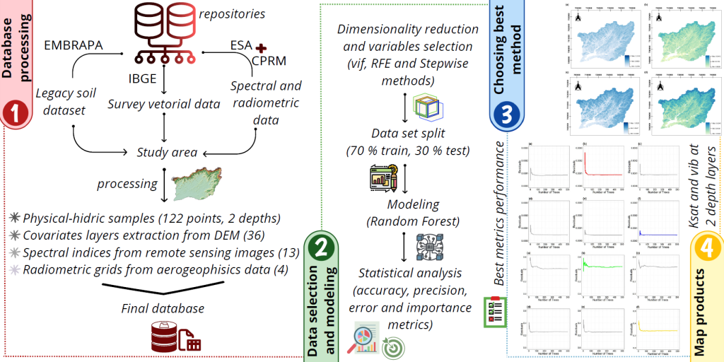
ABSTRACT Pedosphere-hydrosphere interface accounts for the association between soil hydrology and landscape, represented by topographic and Remote Sensing data support and integration. This study aimed to analyze different statistical radiometric and spectral data selection methods and dimensionality reduce environment-related data to support the classification of soil physical-hydric properties, such as soil basic infiltration rate (bir) and saturated hydraulic conductivity (Ksat); as well as to act in data mining processes applied to hydropedological properties digital mapping. Accordingly, research integrated information from […]
Soil loss as a desertification risk indicator: mapping and simulation in the Salitre River Sub-Basin, Northeast Brazil
Márcio Lima Rios ![]() , Alisson Jadavi Pereira da Silva
, Alisson Jadavi Pereira da Silva ![]() , Vagson Luiz Carvalho-Santos
, Vagson Luiz Carvalho-Santos ![]()
26/May/2020
ABSTRACT Discussions on desertification frequently highlight soil erosion as a striking feature of this phenomenon. In particular, the high spatial density of gullies represents a strong indication of the formation of desertification hotspots. In this study, through field activities and Monte Carlo simulations, we estimated the volume of soil loss by linear erosion on the slopes of the middle course of the Salitre river in the North of Bahia State. This estimative contributes to the recognition of a desertification process […]
Estimates of Annual Soil Loss Rates in the State of São Paulo, Brazil
12/Dec/2016
ABSTRACT: Soil is a natural resource that has been affected by human pressures beyond its renewal capacity. For this reason, large agricultural areas that were productive have been abandoned due to soil degradation, mainly caused by the erosion process. The objective of this study was to apply the Universal Soil Loss Equation to generate more recent estimates of soil loss rates for the state of São Paulo using a database with information from medium resolution (30 m). The results showed […]
Three-dimensional interpolation of soil data: fertility and pedomorphological features in southern Brazil
01/Aug/2014
The graphical representation of spatial soil properties in a digital environment is complex because it requires a conversion of data collected in a discrete form onto a continuous surface. The objective of this study was to apply three-dimension techniques of interpolation and visualization on soil texture and fertility properties and establish relationships with pedogenetic factors and processes in a slope area. The GRASS Geographic Information System was used to generate three-dimensional models and ParaView software to visualize soil volumes. Samples […]
Soil-geomorphological relationships and pedoforms distribution in the ecological station of águas emendadas, Distrito Federal
01/Jun/2012
The soil distribution model of the landscape of the Distrito Federal (DF) is influenced by the geomorphological partitioning and geological substrate. The in-depth understanding of pedoforms helps in detailed or semi-detailed soil surveys and mapping of a region. The available pedological mapping of the DF, established in 1978, scale 1:100.00, is still the main source of pedological information of the DF, however, often it cannot meet the needs of the various soil studies, due to the low scale. Thus, the […]
Suitability for reforestation of the canal do Cunha and canal do Mangue watersheds, state of Rio de Janeiro
01/Jun/2005
The suitability for reforestation of parts of the North Slope of the Tijuca neighborhood not covered by buildings, the Mangue and Cunha watersheds, was studied. The plan was to subsidize the “Mutirão” Reforestation Program of the Environmental Department of Rio de Janeiro Municipality. Nutrient deficiency, water deficiency, erosion susceptibility and management impediments were considered in the evaluation of land suitability. The limitation degrees were evaluated for the components of soil survey units, considering soil and landscape information from the available […]
Spatial and temporal-time analysis of land use in part of the semi-arid region of Ceará State, Brazil
01/Apr/2004
The vegetation cover plays a key role in protection and conservation of natural resources, particularly concerning soils. This study had as objective to analyze space and time dimensions of anthropic influence on the vegetation cover in part of the semi-arid region of the Ceará State, Brazil. LANDSAT TM-5 satellite images of 1985 and 1994 combined with geoprocessing techniques were used to verify the hypothesis of intensification of environmental degradation. Maps of the vegetation cover, land use, soils, and hydrography were […]
Application of a comparative index in evaluation of land degradation risk
01/Dec/1998
The determination of land degradation risk in a watershed is an important factor in environmental and agricultural land-use planning. The current trend is to analyze the necessary information for land evaluation in a less subjective way and compatible with geoprocessing techniques. However, criteria and parameters used to quantitatively evaluate the land degradation risk at the watershed scale and based on Geographic Information Systems (GIS) still need to be better defined. The objective of this study, conducted in the second semester […]