

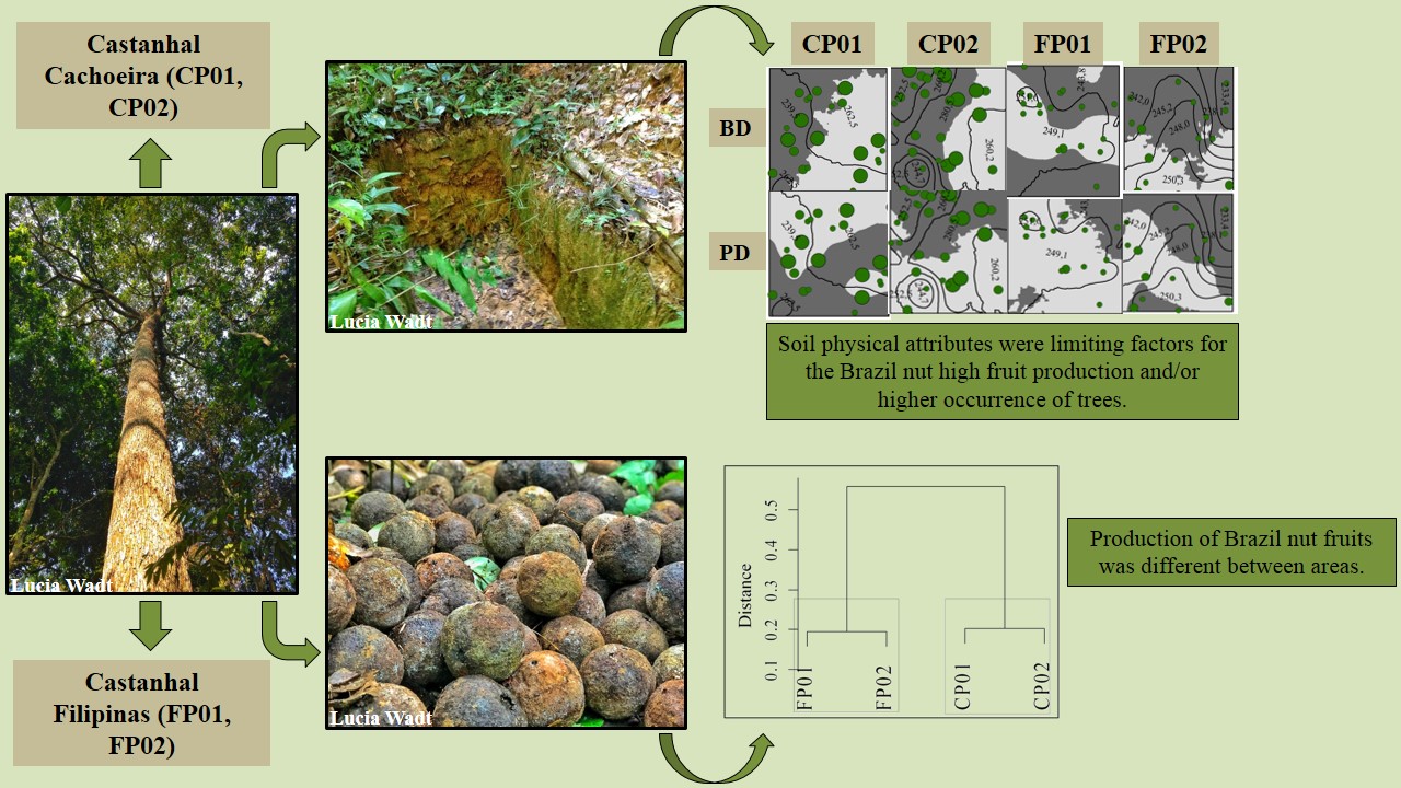
Soil classes and properties explain the occurrence and fruit production of Brazil nut
Camila Santos da Silva ![]() , Lucielio Manoel da Silva
, Lucielio Manoel da Silva ![]() , Lucia Helena de Oliveira Wadt
, Lucia Helena de Oliveira Wadt ![]() , Daniela Popim Miqueloni
, Daniela Popim Miqueloni ![]() , Katia Emidio da Silva
, Katia Emidio da Silva ![]() , Marcos Gervasio Pereira
, Marcos Gervasio Pereira ![]()
13/Aug/2021
ABSTRACT Soil properties and classes can influence the occurrence of plants and the production of Brazil nut fruits and may have a different distribution between sites. This study aimed to evaluate the relationship of plants’ occurrence, production of Brazil nut fruits, and spatial variability of the properties in different soil classes in two Brazil nut stand in the state of Acre, Brazil. The study was conducted in two plots in two native Brazil nut stand, Cachoeira (CP01 and CP02 – […]
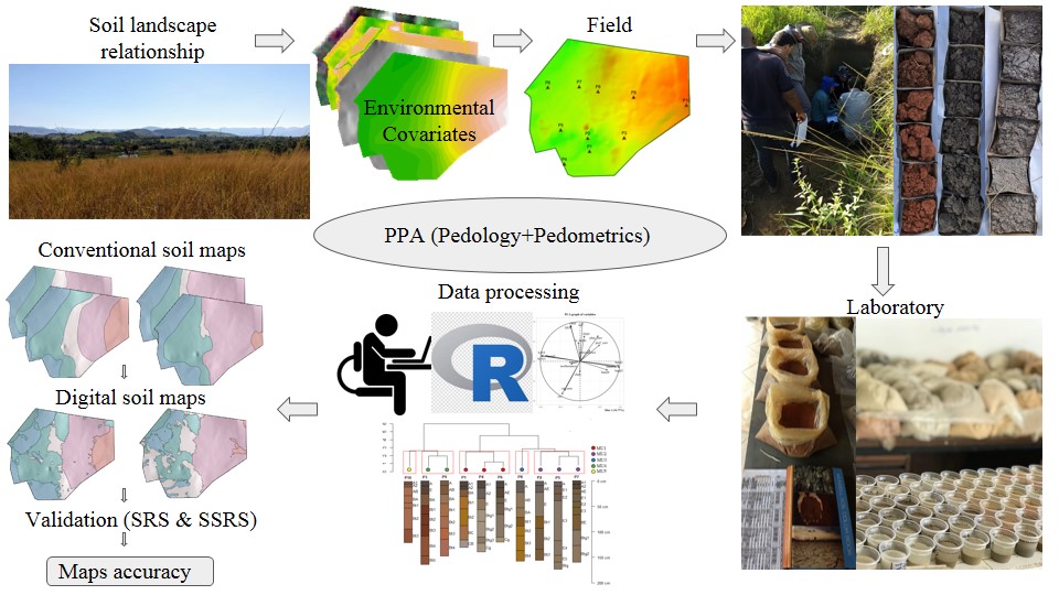
Training pedologist for soil mapping: Contextualizing methods and its accuracy using the project pedagogy approach
Elias Mendes Costa ![]() , Marcos Bacis Ceddia
, Marcos Bacis Ceddia ![]() , Felipe Nascimento dos Santos
, Felipe Nascimento dos Santos ![]() , Laiz de Oliveira Silva
, Laiz de Oliveira Silva ![]() , Igor Prata Terra de Rezende
, Igor Prata Terra de Rezende ![]() , Douglath Alves Correa Fernandes
, Douglath Alves Correa Fernandes ![]()
10/Mar/2021
ABSTRACT There is a growing demand for more detailed knowledge about soils, their functions, and connections with human activities and environmental services. In Brazil, where soil survey and mapping have been scarce since the 1990s, there is a remarkable sense of urgency. Recently, a national soil program was created (PronaSolos) to attend to the massive demand for soil information. PronaSolos is an effort to return to the systematic soil mapping of the national territory, which requires many pedologists who master […]
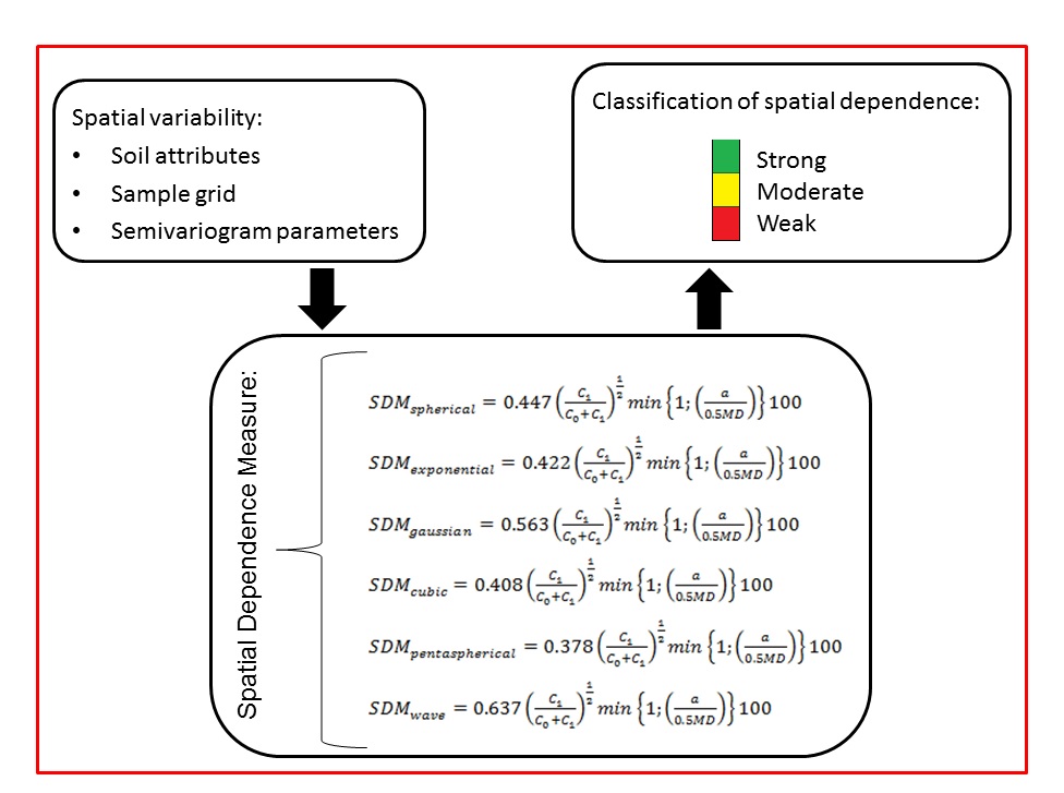
Geostatistical-based index for spatial variability in soil properties
Edemar Appel Neto ![]() , Enio Seidel Junior
, Enio Seidel Junior ![]() , Marcelo Silva de Oliveira
, Marcelo Silva de Oliveira ![]()
15/Sep/2020
ABSTRACT The assessment of spatial variability of environmental variables such as soil properties is important for site-specific management. A geostatistical index that allows quantifying and characterizing the structure of spatial variability is fundamental in this context. Thus, this study aimed to develop a new spatial dependency index, called the Spatial Dependence Measure (SDM) for the spherical, exponential, Gaussian, cubic, pentaspherical, and wave semivariogram models; and comparing it with some of the indexes available in the literature. The SDM is also […]
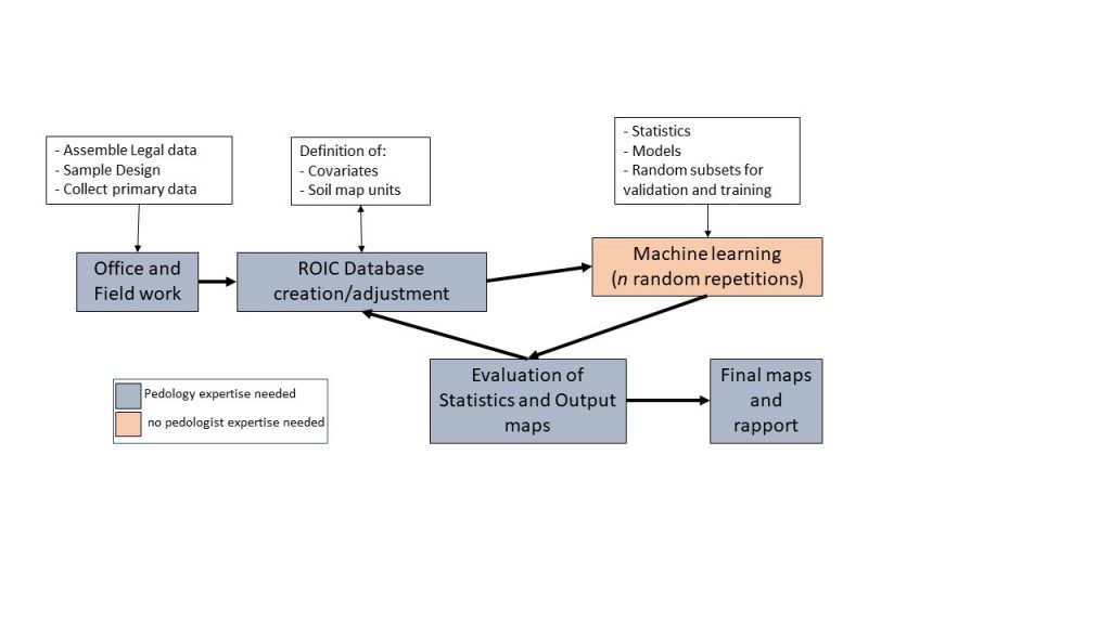
Sample design effects on soil unit prediction with machine: randomness, uncertainty, and majority map
Waldir de Carvalho Junior ![]() , Nilson Rendeiro Pereira
, Nilson Rendeiro Pereira ![]() , Elpidio Inacio Fernandes Filho
, Elpidio Inacio Fernandes Filho ![]() , Braz Calderano Filho
, Braz Calderano Filho ![]() , Helena Saraiva Koenow Pinheiro
, Helena Saraiva Koenow Pinheiro ![]() , Cesar da Silva Chagas
, Cesar da Silva Chagas ![]() , [...]
, [...]
07/Aug/2020
ABSTRACT Notwithstanding the importance of soil surveys, advances in digital soil mapping have mainly focused on mapping soil attributes or properties rather than developing digital maps of soil units or soil classes. The purpose of this research was to develop digital soil unit maps based on primary soil data collection in areas without previously collected soil information. The covariate variability, the random effect across the data subset and the map outputs were the focuses of this study. We used five […]
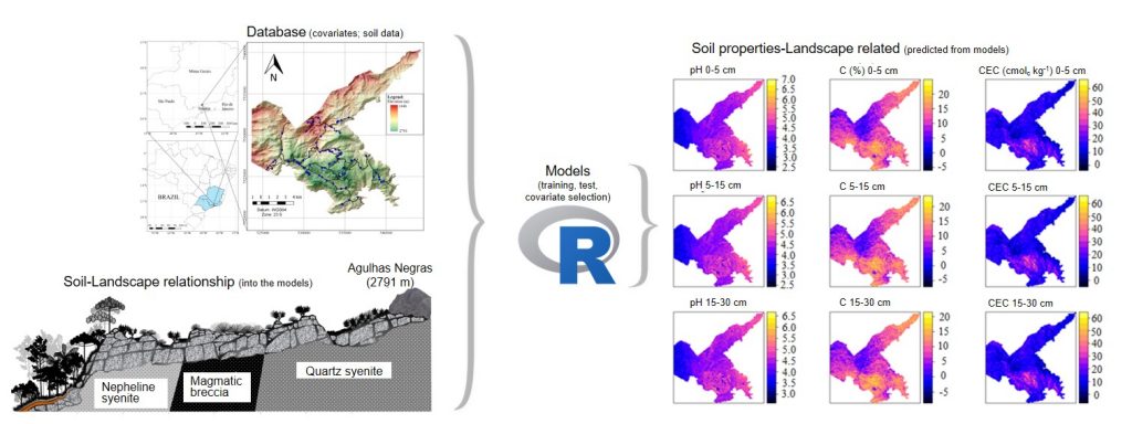
Mapping soil properties in a poorly-accessible area
Elias Mendes Costa ![]() , Helena Saraiva Koenow Pinheiro
, Helena Saraiva Koenow Pinheiro ![]() , Lúcia Helena Cunha dos Anjos
, Lúcia Helena Cunha dos Anjos ![]() , Robson Altiellys Tosta Marcondes
, Robson Altiellys Tosta Marcondes ![]() , Yuri Andrei Gelsleichter
, Yuri Andrei Gelsleichter ![]()
03/Feb/2020
ABSTRACT Soil maps are important to evaluate soil functions and support decision-making process, particularly for soil properties such as pH, carbon content (C), and cation exchange capacity (CEC), but the spatial resolution and soil depth should meet the needs of users. On another hand, the efficiency of statistical models to create soil maps, with an acceptable level of accuracy, often require a large number of samples with an appropriate distribution across the area of interest. However, accessibility for sampling can […]
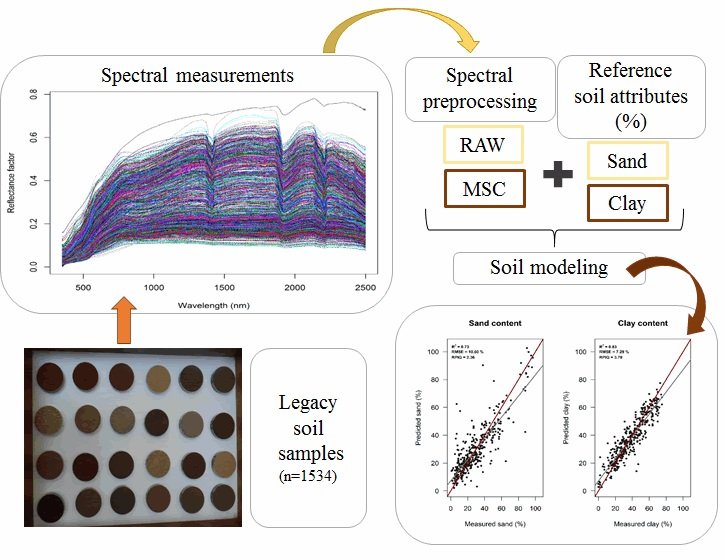
A Regional Legacy Soil Dataset for Prediction of Sand and Clay Content with Vis-Nir-Swir, in Southern Brazil
Elisângela Benedet Silva ![]() , Élvio Giasson
, Élvio Giasson ![]() , André Carnieletto Dotto
, André Carnieletto Dotto ![]() , Alexandre ten Caten
, Alexandre ten Caten ![]() , José Alexandre Melo Demattê
, José Alexandre Melo Demattê ![]() , Ivan Luiz Zilli Bacic
, Ivan Luiz Zilli Bacic ![]() , [...]
, [...]
12/Aug/2019
ABSTRACT The success of soil prediction by VIS-NIR-SWIR spectroscopy has led to considerable investment in large soil spectral libraries. The aims of this study were 1) to develop a soil VIS-NIR-SWIR spectroscopy approach using legacy soil samples to improve spectral soil information in a regional scale; (2) to compare six spectral preprocessing techniques; and (3) to compare the performance of linear and non-linear multivariate models for prediction of sand and clay content. A total of 1,534 legacy soil samples, stored […]
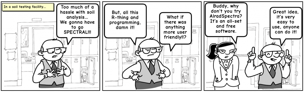
AlradSpectra: a Quantification Tool for Soil Properties Using Spectroscopic Data in R
André Carnieletto Dotto ![]() , Ricardo Simão Diniz Dalmolin
, Ricardo Simão Diniz Dalmolin ![]() , Alexandre ten Caten
, Alexandre ten Caten ![]() , Diego José Gris
, Diego José Gris ![]() , Luis Fernando Chimelo Ruiz
, Luis Fernando Chimelo Ruiz ![]()
23/Jul/2019
ABSTRACT Soil reflectance spectroscopy has become an innovative method for soil property quantification supplying data for studies in soil fertility, soil classification, digital soil mapping, while reducing laboratory time and applying a clean technology. This paper describes the implementation of a Graphical User Interface (GUI) using R named AlradSpectra. It contains several tools to process spectroscopic data and generate models to predict soil properties. The GUI was developed to accomplish tasks such as perform a large range of spectral preprocessing […]
Selection of Environmental Covariates for Classifier Training Applied in Digital Soil Mapping
26/Nov/2018
ABSTRACT A large number of predictor variables can be used in digital soil mapping; however, the presence of irrelevant covariables may compromise the prediction of soil types. Thus, algorithms can be applied to select the most relevant predictors. This study aimed to compare three covariable selection systems (two filter algorithms and one wrapper algorithm) and assess their impacts on the predictive model. The study area was the Lajeado River Watershed in the state of Rio Grande do Sul, Brazil. We […]
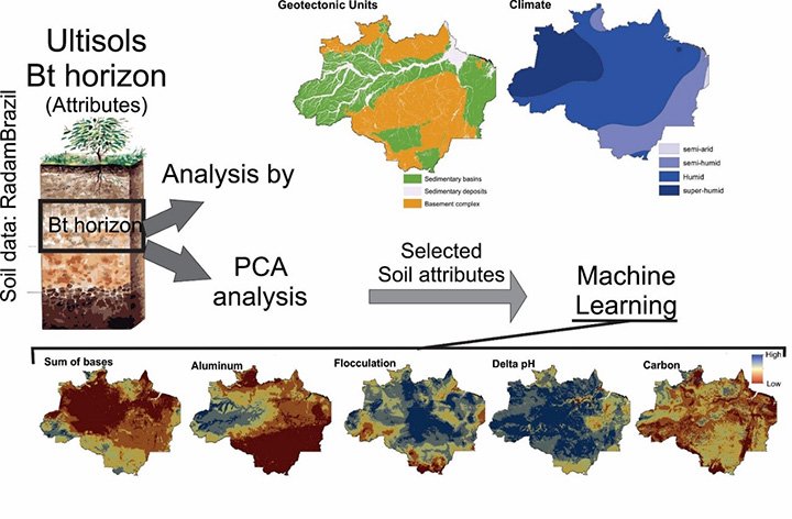
Multivariate Analysis and Machine Learning in Properties of Ultisols (Argissolos) of Brazilian Amazon
26/Nov/2018
ABSTRACT: Ultisols are the most common soil order in the Brazilian Amazon. The Legal Amazon (LA) has an area of 5 × 10⁶ km2, with few accessible areas, which restricts studies of soils at a detailed level. The pedological properties can be estimated more efficiently using statistical procedures and machine learning techniques, tools which are capable of recognizing patterns in a large soil database. We analyzed the main chemical and physical properties of the B horizons of the Ultisols of […]
Digital Soil Mapping of Soil Properties in the “Mar de Morros” Environment Using Spectral Data
08/Nov/2018
ABSTRACT Quantification of soil properties is essential for better understanding of the environment and better soil management. The conventional techniques of laboratory analysis are sometimes costly and detrimental to the environment. Thus, development of new techniques for soil analysis that do not generate residues, such as spectroscopy, is increasingly necessary as a viable way to estimate a wide range of soil properties. The objective of this study was to predict the levels of organic carbon (OC), clay, and extractable phosphorus […]