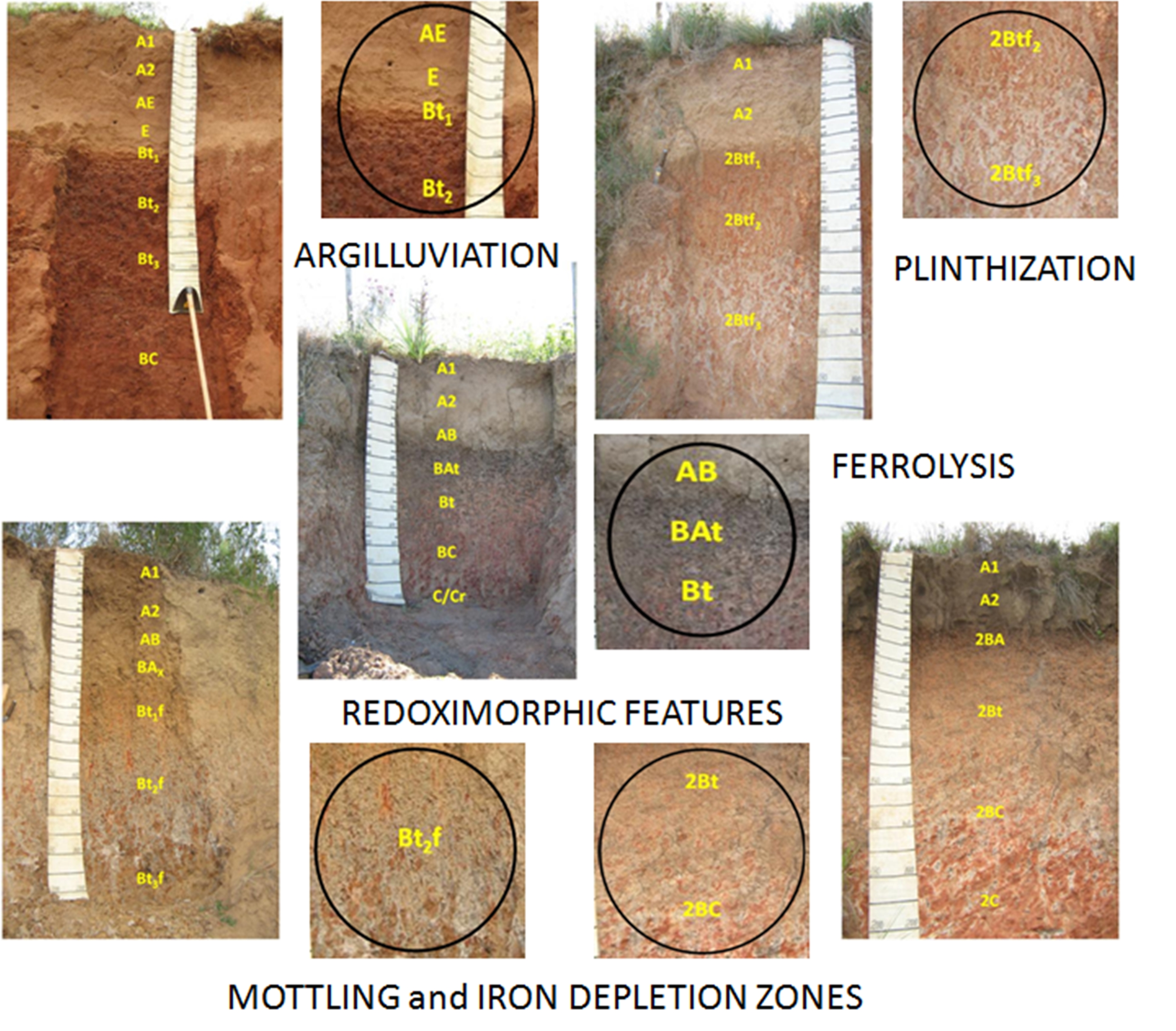
Epi and endosaturation affecting redoximorphic features and pedogenesis in subtropical soils with high textural contrast developed from sedimentary rocks
Jaime Antonio de Almeida ![]() , Pablo Grahl dos Santos
, Pablo Grahl dos Santos ![]()
11/Nov/2021
ABSTRACT Soils in the Depressão Central and Campanha Gaúcha in Rio Grande do Sul State, Brazil, developed from sedimentary rocks are mainly Alfisols (Luvissolos, Planossolos and Plintossolos) and Ultisols (Argissolos) with high textural contrast between A and/or E horizons and clayey B horizons. Red Ultisols dominate in well-drained areas in the summit. But many soils present redoximorphic features on the backslope and footslope, with mottled and/or nodules similar to plinthite due to the oscillating of the water table above the […]
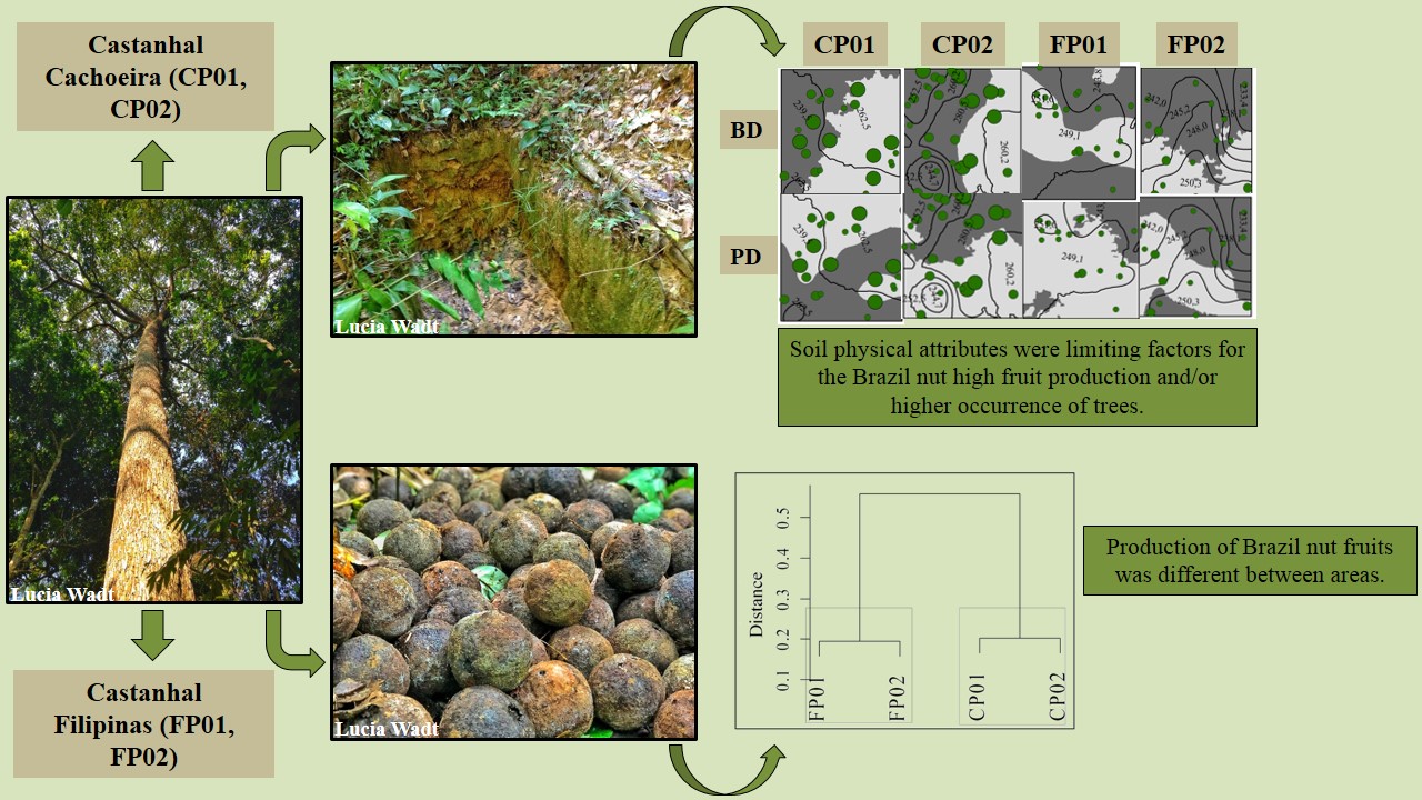
Soil classes and properties explain the occurrence and fruit production of Brazil nut
Camila Santos da Silva ![]() , Lucielio Manoel da Silva
, Lucielio Manoel da Silva ![]() , Lucia Helena de Oliveira Wadt
, Lucia Helena de Oliveira Wadt ![]() , Daniela Popim Miqueloni
, Daniela Popim Miqueloni ![]() , Katia Emidio da Silva
, Katia Emidio da Silva ![]() , Marcos Gervasio Pereira
, Marcos Gervasio Pereira ![]()
13/Aug/2021
ABSTRACT Soil properties and classes can influence the occurrence of plants and the production of Brazil nut fruits and may have a different distribution between sites. This study aimed to evaluate the relationship of plants’ occurrence, production of Brazil nut fruits, and spatial variability of the properties in different soil classes in two Brazil nut stand in the state of Acre, Brazil. The study was conducted in two plots in two native Brazil nut stand, Cachoeira (CP01 and CP02 – […]
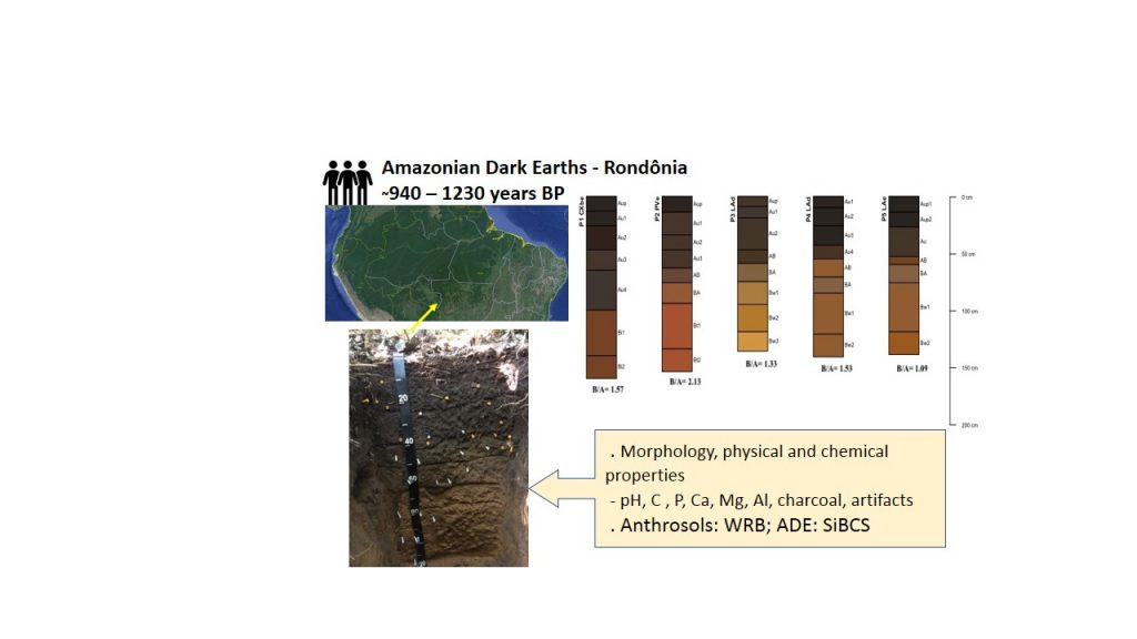
Amazonian Dark Earths in Rondônia State: Soil properties, carbon dating and classification
Rafael de Souza Cavassani ![]() , Lúcia Helena Cunha dos Anjos
, Lúcia Helena Cunha dos Anjos ![]() , Marcos Gervasio Pereira
, Marcos Gervasio Pereira ![]() , Andrés Calderin Garcia
, Andrés Calderin Garcia ![]()
29/Jun/2021
ABSTRACT Throughout the Amazon region, dark-colored soils with increased fertility are identified and referred as Amazonian Dark Earths (ADE). These unique soils are characterized by an anthropic surface horizon with dark colors, presence of charcoal and artifacts, in contrast with surrounding non-ADE soils. The ADEs show extraordinary properties such as the capacity of maintaining the dark colors and high nutrient levels after years of farming, even under the highly favorable climatic conditions for oxidation of organic matter and weathering of […]
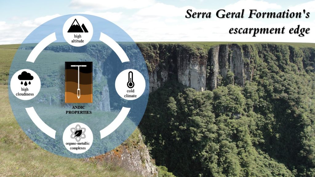
Andic properties in soils with histic horizon “O” in the highlands of Southern Brazil
Jaime Barros dos Santos Junior ![]() , Jaime Antonio de Almeida
, Jaime Antonio de Almeida ![]()
31/Mar/2021
ABSTRACT Soils with andic properties are characterized by a low apparent density, variable charges, large amounts of allophanes, imogolite, ferrihydrite, and/or organo-metallic complexes with Al, and present high phosphate retention. Soils derived from non-pyroclastic materials rich in silicates, formed under a cold and humid climate, a large amount of organic carbon, acid weathering, andic properties can manifest when a large amount of Al is present in the form of organo-metallic complexes. This study aimed to evaluate the characteristics and geographical […]
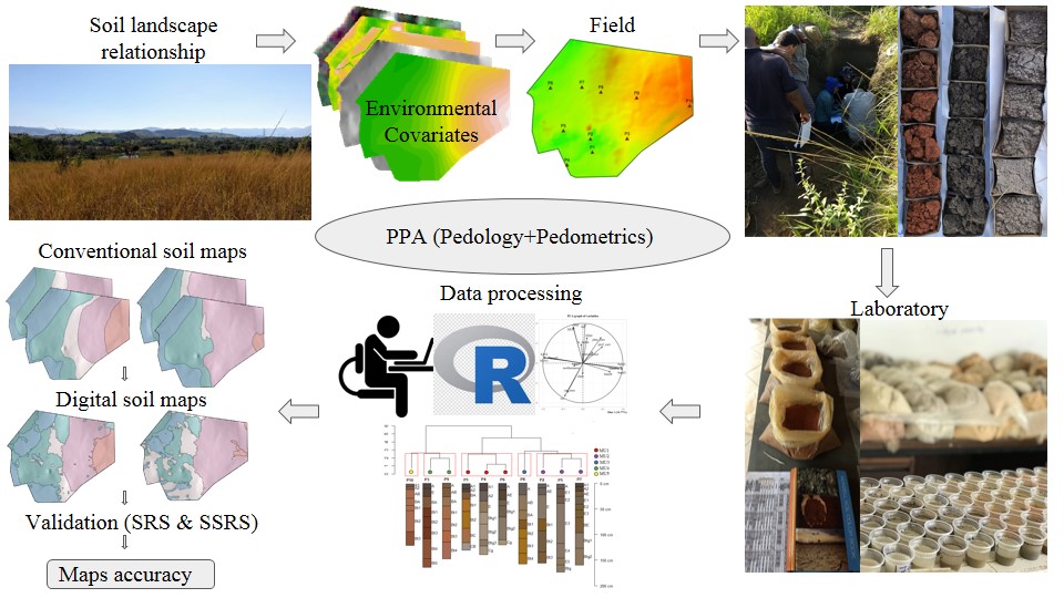
Training pedologist for soil mapping: Contextualizing methods and its accuracy using the project pedagogy approach
Elias Mendes Costa ![]() , Marcos Bacis Ceddia
, Marcos Bacis Ceddia ![]() , Felipe Nascimento dos Santos
, Felipe Nascimento dos Santos ![]() , Laiz de Oliveira Silva
, Laiz de Oliveira Silva ![]() , Igor Prata Terra de Rezende
, Igor Prata Terra de Rezende ![]() , Douglath Alves Correa Fernandes
, Douglath Alves Correa Fernandes ![]()
10/Mar/2021
ABSTRACT There is a growing demand for more detailed knowledge about soils, their functions, and connections with human activities and environmental services. In Brazil, where soil survey and mapping have been scarce since the 1990s, there is a remarkable sense of urgency. Recently, a national soil program was created (PronaSolos) to attend to the massive demand for soil information. PronaSolos is an effort to return to the systematic soil mapping of the national territory, which requires many pedologists who master […]
Calcination as an alternative method to classify Spodosols on the second categorical level
Daniel Alexandre Heberle ![]() , Jaime Antonio de Almeida
, Jaime Antonio de Almeida ![]() , Pablo Vidal Torrado
, Pablo Vidal Torrado ![]()
11/Nov/2020
ABSTRACT The classification of Spodosols on the second categorical level (suborder), according to the Brazilian Soil Classification System (SiBCS), is done by observing the colors of genetic horizons in the field. The presence or absence of iron oxides is the main factor for this classification, and the color of the horizon is the criterion currently adopted. However, the simple observation of color in the field can be mistaken and cause an error in the definition of the second categorical level. […]
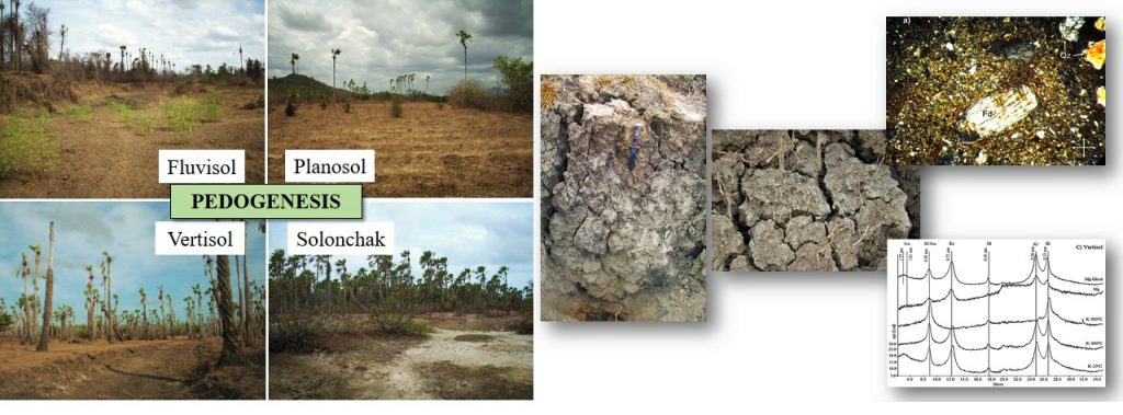
Alluvial soil formation in the plains of northeastern Brazil
Rafael Cipriano-Silva ![]() , Gustavo Souza Valladares
, Gustavo Souza Valladares ![]() , Antônio Carlos de Azevedo
, Antônio Carlos de Azevedo ![]() , Lúcia Helena Cunha dos Anjos
, Lúcia Helena Cunha dos Anjos ![]() , Marcos Gervasio Pereira
, Marcos Gervasio Pereira ![]() , Carlos Roberto Pinheiro Junior
, Carlos Roberto Pinheiro Junior ![]()
23/Oct/2020
ABSTRACT Soils in alluvial plains of the lower course of the Acaraú River, Ceará State, Brazil, are weakly developed and have a complex distribution in the landscape. This study reports the pedogenic characterization of such soils in an effort to understand their formation. Soil pits were opened in four representative sites, profile morphology was described, and soil samples were collected for chemical, physical, mineralogical, and micromorphological analyses. All profiles had weak pedogenic development, as inferred from their morphological characteristics, lack […]
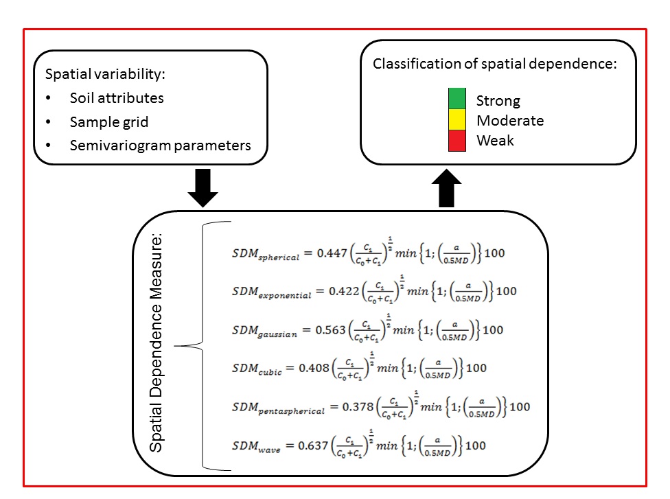
Geostatistical-based index for spatial variability in soil properties
Edemar Appel Neto ![]() , Enio Seidel Junior
, Enio Seidel Junior ![]() , Marcelo Silva de Oliveira
, Marcelo Silva de Oliveira ![]()
15/Sep/2020
ABSTRACT The assessment of spatial variability of environmental variables such as soil properties is important for site-specific management. A geostatistical index that allows quantifying and characterizing the structure of spatial variability is fundamental in this context. Thus, this study aimed to develop a new spatial dependency index, called the Spatial Dependence Measure (SDM) for the spherical, exponential, Gaussian, cubic, pentaspherical, and wave semivariogram models; and comparing it with some of the indexes available in the literature. The SDM is also […]
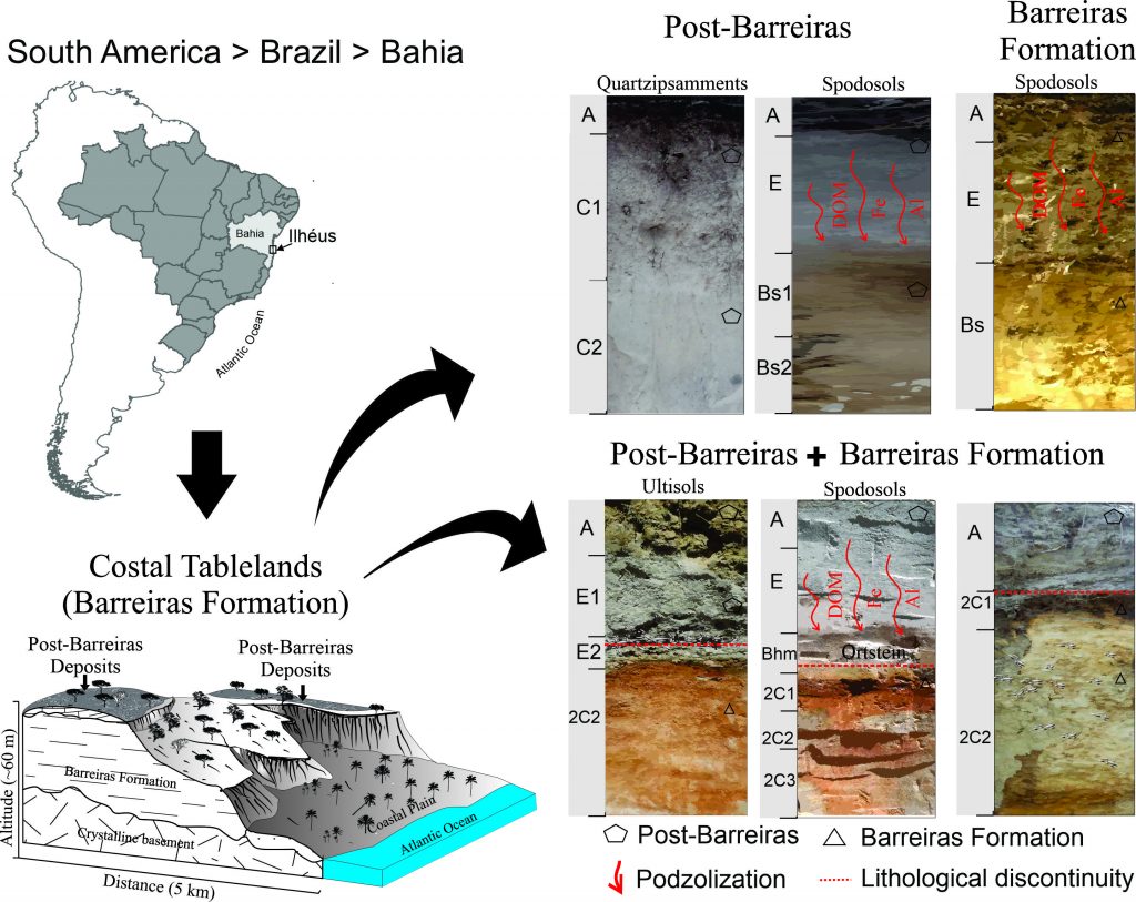
Association of Post-Barreiras and Barreiras Formation strata and influence on soil genesis, Southern Bahia – Brazil
Cristiano Marcelo Pereira de Souza ![]() , Liovando Marciano da Costa
, Liovando Marciano da Costa ![]() , Francis Henrique Tenório Firmino
, Francis Henrique Tenório Firmino ![]() , Carlos César Uchôa de Lima
, Carlos César Uchôa de Lima ![]() , Ana Maria Souza dos Santos Moreau
, Ana Maria Souza dos Santos Moreau ![]() , Marcos Esdras Leite
, Marcos Esdras Leite ![]()
01/Sep/2020
ABSTRACT The term Post-Barreiras is a definition for sediments above the deposits of the Barreiras Formation, and the genesis of soils in these environments must be related to sedimentary deposition. Our objective was to apply multi-technique analyses to characterize the sediments and soils to understand pedogenesis in these environments. We analysed sedimentological parameters and the geochronology of sediments. Morphological, chemical, and mineralogical analyses allowed the characterization of the soil. Also, these data supported the analysis of lithological discontinuity. We considered […]
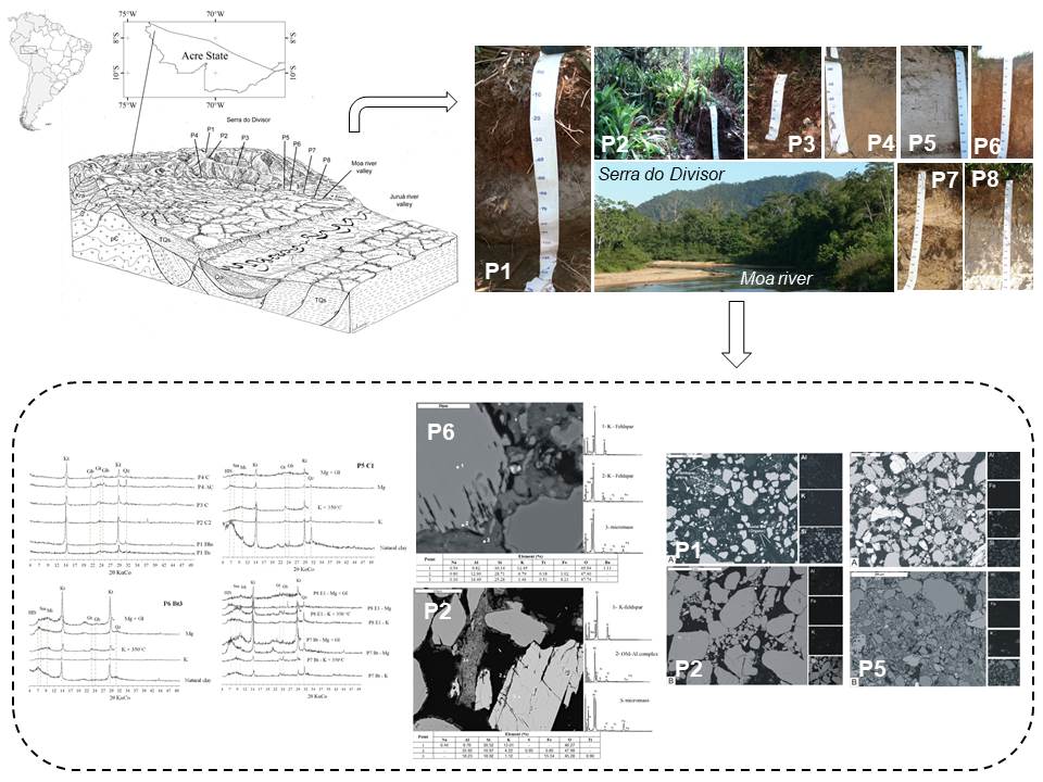
Genesis and micropedology of soils at Serra do Divisor and Moa river floodplain, northwestern Acre, Brazilian Amazonia
Bruno Araujo Furtado de Mendonça ![]() , Carlos Ernesto Gonçalves Reynaud Schaefer
, Carlos Ernesto Gonçalves Reynaud Schaefer ![]() , Elpídio Inácio Fernandes-Filho
, Elpídio Inácio Fernandes-Filho ![]() , Felipe Nogueira Bello Simas
, Felipe Nogueira Bello Simas ![]() , Eufran Ferreira do Amaral
, Eufran Ferreira do Amaral ![]()
28/Aug/2020
ABSTRACT The northwestern part of the Acre State (Brazil) possesses singular soils in Brazilian Amazonia, but have been very little studied. This study aimed to discuss the genesis and some micropedological aspects of the soils from Serra do Divisor and adjacent floodplain soils of the Moa river, to enhance the knowledge on their formation. A toposequence of soils ranging from the uppermost part of sub-Andean Serra do Divisor to the Alluvial soils of Moa river floodplain was studied, regarding chemical, […]