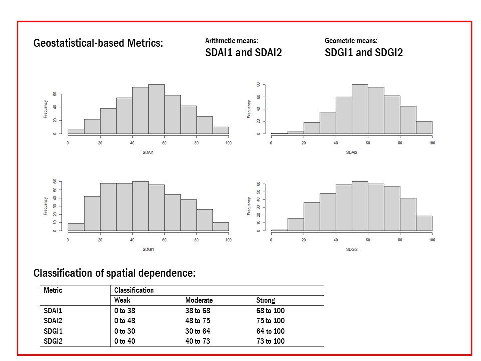
Proposal and validation of geostatistical-based metrics to quantify within-field variability
Enio Júnior Seidel ![]() , Marcelo Silva de Oliveira
, Marcelo Silva de Oliveira ![]()
28/out/2025
ABSTRACT Metrics are fundamental to quantify and classify the spatial dependence of soil and agricultural attributes. This study aimed to propose and validate metrics based on two distinct approaches, one additive, which considers the arithmetic mean of the vertical and horizontal components, and the other multiplicative, which considers the geometric mean of the vertical and horizontal components of the semivariogram. Furthermore, we intend to propose the classification of spatial dependence based on the categorization of these metrics. Finally, a function […]
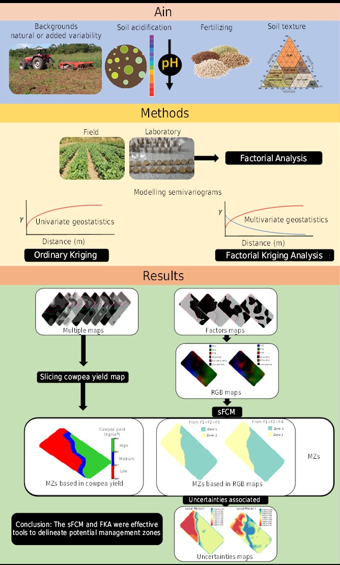
Delineation of potential management zones for cowpea by factorial kriging and spatial Fuzzy C-Means of yield and soil chemical and texture properties
João Fernandes da Silva Júnior ![]() , Thiago Thomé da Silva
, Thiago Thomé da Silva ![]() , Devid Jackson da Silva Sousa
, Devid Jackson da Silva Sousa ![]() , Rose Luiza Moraes Tavares
, Rose Luiza Moraes Tavares ![]() , Benedito Dutra Luz de Souza
, Benedito Dutra Luz de Souza ![]() , Daniel Pereira Pinheiro
, Daniel Pereira Pinheiro ![]()
14/jan/2025
ABSTRACT In precision agriculture, accurate delineation of management zones and understanding spatial variability of soil properties and crop yields are critical for optimizing resource allocation and improving productivity. Spatial variability of different environmental factors (soil and plants) is evident in several studies. Associations between the texture and chemical properties of the soil and cowpea yield have been tested, but a large, unexplained variance of ranges between kriged maps is usually reported. This suggests that a deeper exploration into the soil […]
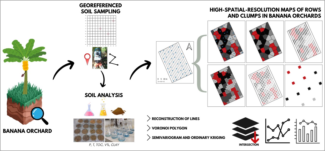
High-resolution banana row maps for the characterization of spatial variability in the field
Eudocio Rafael Otavio da Silva ![]() , Murilo Machado de Barros
, Murilo Machado de Barros ![]() , Gabriele Oliveira Silva
, Gabriele Oliveira Silva ![]() , André Felipe de Sousa Vaz
, André Felipe de Sousa Vaz ![]() , Marcos Gervasio Pereira
, Marcos Gervasio Pereira ![]()
25/nov/2024
ABSTRACT Precision agriculture (PA) practices in banana production chains have received limited attention. Based on the literature, the investigation of spatial and temporal variability in banana orchards should be customized according to the characteristics of the crop. This study aimed to develop and evaluate methods for mapping the spatial variability in soil properties at row- and clump-resolutions in a banana orchard, and to generate row and clump maps with high-spatial-resolution soil property information. A banana orchard was investigated, and georeferenced […]
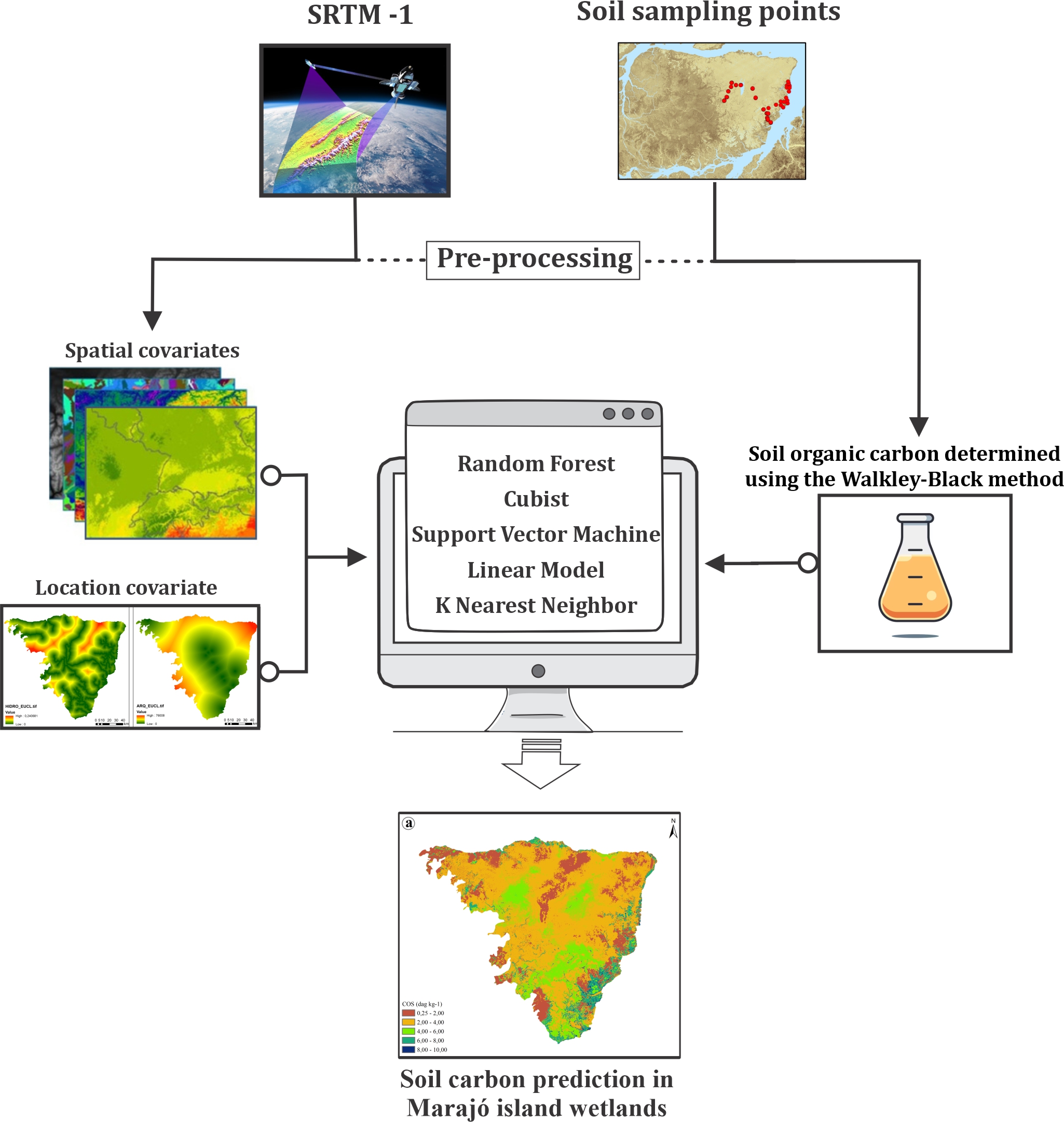
Soil carbon prediction in Marajó island wetlands
David Lukas de Arruda ![]() , João Carlos Ker
, João Carlos Ker ![]() , Gustavo Vieira Veloso
, Gustavo Vieira Veloso ![]() , Renata Jordan Henriques
, Renata Jordan Henriques ![]() , Elpídio Inácio Fernandes-Filho
, Elpídio Inácio Fernandes-Filho ![]() , Danilo de Lima Camêlo
, Danilo de Lima Camêlo ![]() , [...]
, [...]
27/ago/2024
ABSTRACT Soil is an important carbon repository in terrestrial ecosystems, serving a fundamental role in the intricate cycling of this elemental component. Wetlands are crucial components of the global carbon cycle, playing a significant role in carbon sequestration due to their remarkable productivity and unique sedimentary structures. Our study focuses on the wetlands east of Marajó island, recognized as the largest fluvial-marine plain in South America. In this study, we applied a methodological framework to optimize SOC content prediction in […]
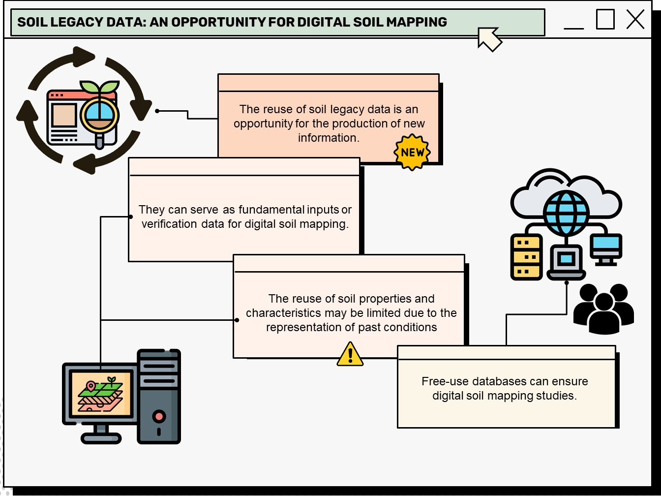
Soil legacy data: An opportunity for digital soil mapping
Beatriz Macêdo Medeiros ![]() , Letícia Sequinatto Rossi
, Letícia Sequinatto Rossi ![]() , Alexandre ten Caten
, Alexandre ten Caten ![]() , Gustavo Eduardo Pereira
, Gustavo Eduardo Pereira ![]() , Elisângela Benedet da Silva
, Elisângela Benedet da Silva ![]() , Kelly Tamires Urbano Daboit
, Kelly Tamires Urbano Daboit ![]()
23/jul/2024
ABSTRACT Soil legacy data is past information on soils available from various sources (e.g. survey reports and maps). When compiled and organized, data obtained through historical retrieval can be used as basic input or validation data for digital soil mapping. A bibliometric analysis of this topic can reveal research patterns, evolution, and scientific contribution, thus mapping the science produced in a specific period and determining the trend in research topics based on search terms. This article presents the characterization of […]
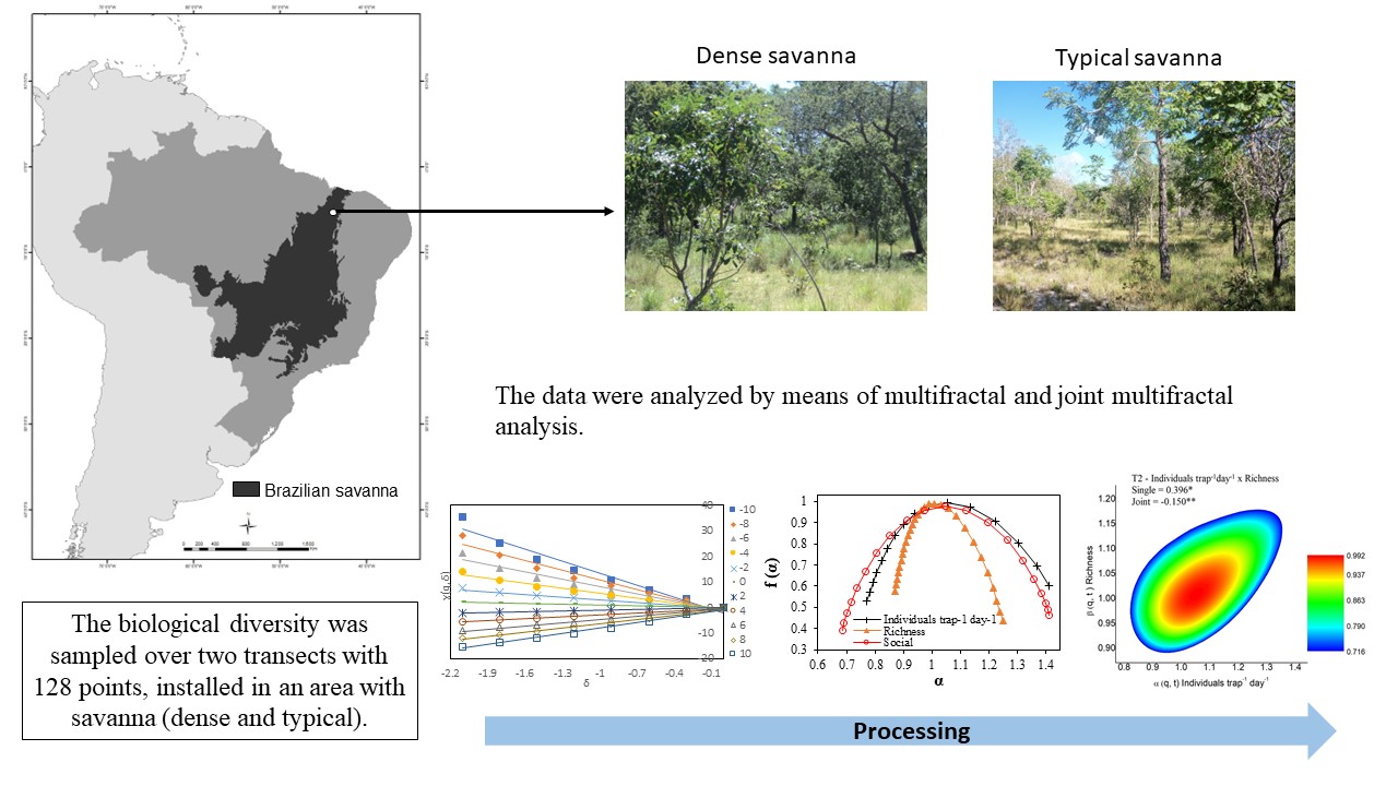
Multifractal and joint analysis of soil arthropod diversity in the Brazilian Savanna
Glécio Machado Siqueira ![]() , Raimunda Alves Silva
, Raimunda Alves Silva ![]()
12/jul/2024
ABSTRACT Soil fauna organisms participate in a series of processes that benefit the physical and chemical soil properties; however, little is known about their spatial variability and scale. This study aimed to characterize the spatial variability of soil fauna from multifractal and joint multifractal analysis in Brazilian Savanna areas. Pitfall traps collected soil fauna in two Savanna formations (dense Savanna and typical Savanna) in two transects with 128 points. Organisms were identified and classified into functional groups (Microphages, Pollinators, Predators […]
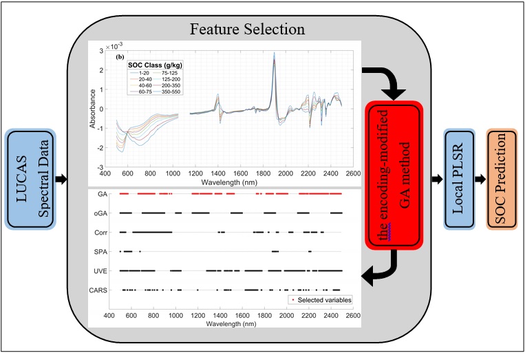
Estimation of soil organic carbon content by Vis-NIR spectroscopy combining feature selection algorithm and local regression method
Baoyang Liu ![]() , Baofeng Guo
, Baofeng Guo ![]() , Renxiong Zhuo
, Renxiong Zhuo ![]() , Fan Dai
, Fan Dai ![]()
07/dez/2023
ABSTRACT Soil organic carbon (SOC) content is a critical parameter for evaluating soil health. However, high redundancy and invalid information in soil hyperspectral data can reduce the accuracy and stability of SOC prediction models. This study developed a global partial least squares regression (PLSR) model and a local PLSR model for agricultural soils in the LUCAS 2015 database. Some variable selection methods were combined with the regression models and their effects on prediction accuracy were explored. In addition, when the […]
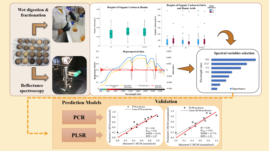
Reflectance spectroscopy in the prediction of soil organic carbon associated with humic substances
Sharon Gomes Ribeiro ![]() , Marcio Regys Rabelo de Oliveira
, Marcio Regys Rabelo de Oliveira ![]() , Letícia Machado Lopes
, Letícia Machado Lopes ![]() , Mirian Cristina Gomes Costa
, Mirian Cristina Gomes Costa ![]() , Raul Shiso Toma
, Raul Shiso Toma ![]() , Isabel Cristina da Silva Araújo
, Isabel Cristina da Silva Araújo ![]() , [...]
, [...]
06/jun/2023
ABSTRACT Understanding organic carbon and predominant humic fractions in the soil allows contributes to soil quality management. Conventional fractionation techniques require time, excessive sampling, and high maintenance costs. In this study, predictive models for organic carbon in humic substances (HS) were evaluated using hyperspectral data as an alternative to chemical fractionation and quantification by wet digestion. Twenty-nine samples of Neossolos Flúvicos (Fluvents) – A1, and 36 samples of Cambissolos (Inceptisols) – A2 were used. The samples were also analyzed jointly, […]
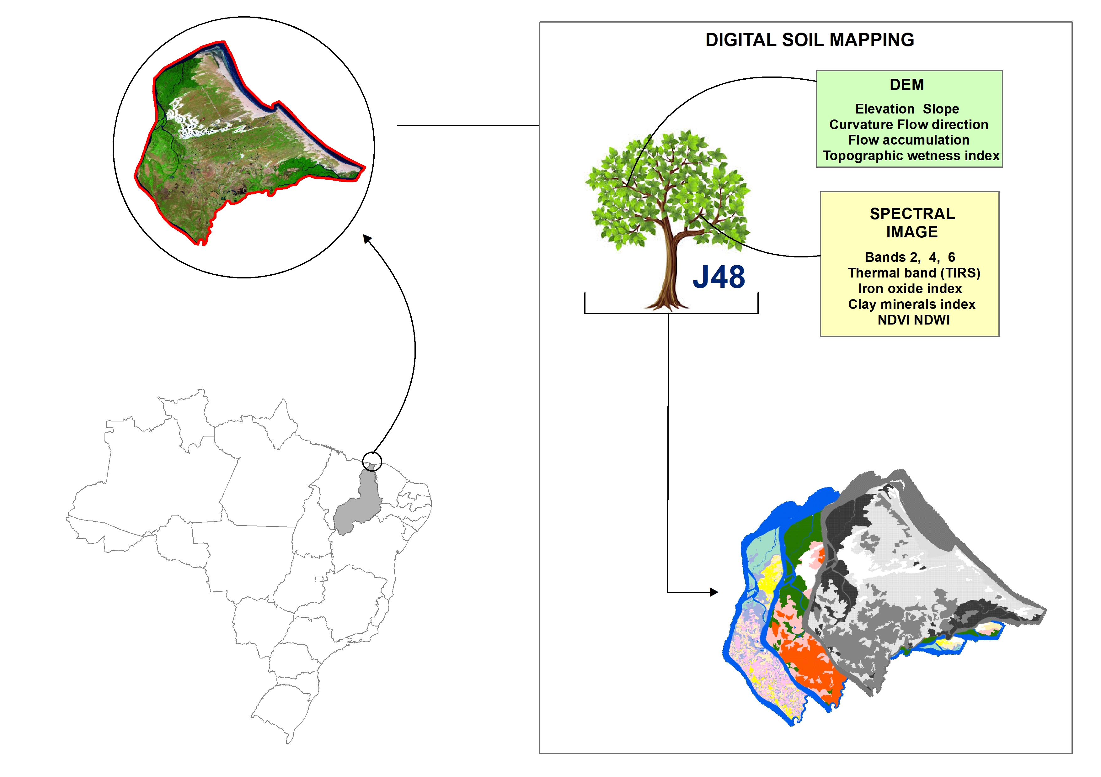
Digital soil mapping for the Parnaíba River delta, Brazilian semiarid region
João Victor Alves Amorim ![]() , Gustavo Souza Valladares
, Gustavo Souza Valladares ![]() , Marcos Gervasio Pereira
, Marcos Gervasio Pereira ![]() , Mirya Grazielle Torres Portela
, Mirya Grazielle Torres Portela ![]() , Andréa Maciel Lima
, Andréa Maciel Lima ![]()
04/abr/2023
ABSTRACT Soil mapping is a permanent demand, but the traditional method does not allow fast execution and low cost. Digital soil mapping (DSM) aims to improve the process by working with models that treat soil spatial variability quantitatively. In this perspective, the objective of the study is to perform DSM of the Parnaíba River Delta, Northeastern Brazil, through the decision tree (DT) integration technique using a set of attributes derived from the digital elevation model (DEM) and satellite images as […]
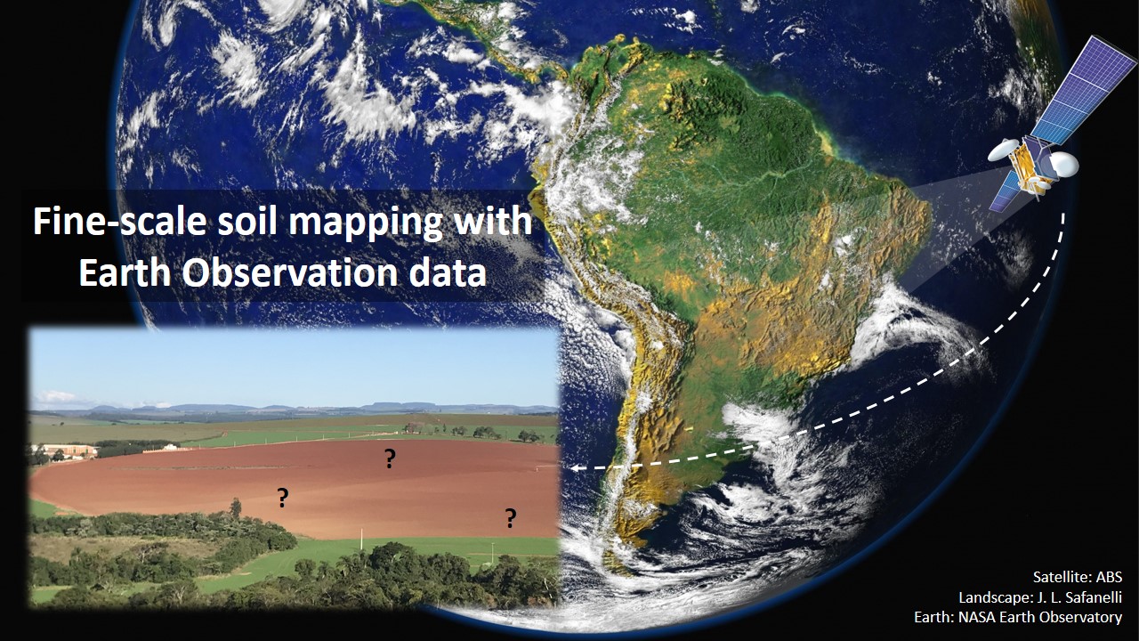
Fine-scale soil mapping with Earth Observation data: a multiple geographic level comparison
José Lucas Safanelli ![]() , José Alexandre Melo Demattê
, José Alexandre Melo Demattê ![]() , Natasha Valadares dos Santos
, Natasha Valadares dos Santos ![]() , Jorge Tadeu Fim Rosas
, Jorge Tadeu Fim Rosas ![]() , Nélida Elizabet Quiñonez Silvero
, Nélida Elizabet Quiñonez Silvero ![]() , Benito Roberto Bonfatti
, Benito Roberto Bonfatti ![]() , [...]
, [...]
24/nov/2021
ABSTRACT Multitemporal collections of satellite images and their products have recently been explored in digital soil mapping. This study aimed to produce a bare soil image (BSI) for the São Paulo State (Brazil) to perform a pedometric analysis for different geographical levels. First, we assessed the potential of the BSI for predicting the surface (0.00-0.20 m) and subsurface (0.80-1.00 m) clay, iron oxides (Fe 2 O 3 ), aluminum (m%) and bases saturation (V%) contents at the state level, which […]