

Training pedologist for soil mapping: Contextualizing methods and its accuracy using the project pedagogy approach
Elias Mendes Costa ![]() , Marcos Bacis Ceddia
, Marcos Bacis Ceddia ![]() , Felipe Nascimento dos Santos
, Felipe Nascimento dos Santos ![]() , Laiz de Oliveira Silva
, Laiz de Oliveira Silva ![]() , Igor Prata Terra de Rezende
, Igor Prata Terra de Rezende ![]() , Douglath Alves Correa Fernandes
, Douglath Alves Correa Fernandes ![]()
10/mar/2021
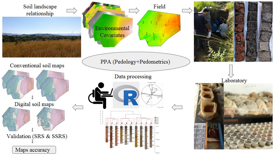
ABSTRACT There is a growing demand for more detailed knowledge about soils, their functions, and connections with human activities and environmental services. In Brazil, where soil survey and mapping have been scarce since the 1990s, there is a remarkable sense of urgency. Recently, a national soil program was created (PronaSolos) to attend to the massive demand for soil information. PronaSolos is an effort to return to the systematic soil mapping of the national territory, which requires many pedologists who master […]
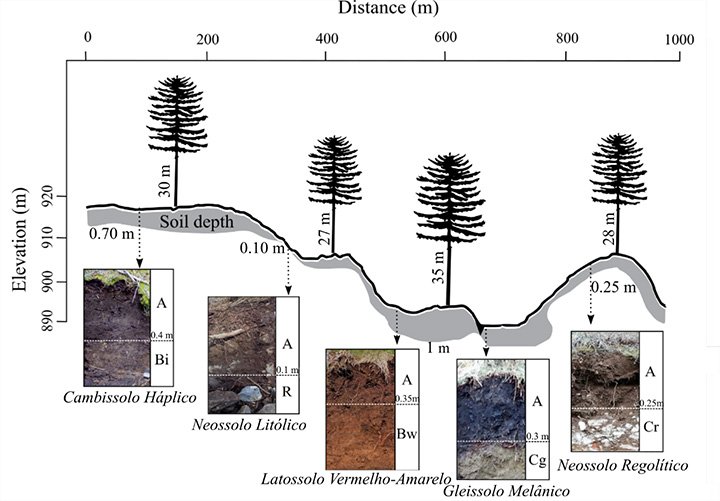
Edaphic and Topographic Factors and their Relationship with Dendrometric Variation of Pinus Taeda L. in a High Altitude Subtropical Climate
26/nov/2018
ABSTRACT The study of the relationships between the yield potential of forest stands and the conditions offered for plant development is fundamental for the adequate management of the forest when aiming at sustainable high yields. However, these relations are not clear, especially in commercial forests, on rugged terrain where relationships between the landscape, soil, and plants are more complex. Considering this, we tested the hypothesis that the morphological aspects of the soil conditioned by topography are the main limiting factors […]
Soils Developed on Geomorphic Surfaces in the Mountain Region of the State of Rio de Janeiro
05/dez/2017
ABSTRACT: The evaluation of soils in representative landscapes constitutes an opportunity to evaluate spatial distribution, discuss formation processes, and apply this knowledge to land use and management. In this sense, from the perspective of an environmentally diversified region, the aim of the present study is to evaluate the occurrence and understand the formation of soils in different geomorphic surfaces of a landscape from a mountain region in the state of Rio de Janeiro. The study was developed in the Pito […]
Comparação entre mapas de solos detalhados obtidos pelos métodos convencional e digital em uma área de geologia complexa
01/out/2013
Uma vez que pedólogos diferentes produzirão, em uma mesma área, mapas de solos distintos, é importante avaliar as divergências existentes entre profissionais e técnicas de mapeamento, dentre elas o Mapeamento Digital de Solos, que vem sendo muito abordada atualmente. Para tanto, compararam-se quatro mapas detalhados de solos (escala 1:10.000) de uma fazenda de 182 ha cultivados com cana-de-açúcar, localizada no município de Rafard, SP, com grande variação do meio físico. Tais mapas foram elaborados independentemente por quatro pedólogos e confrontados […]
Variabilidade espacial de atributos físicos de um argissolo sob diferentes curvaturas do relevo
01/jun/2010
A influência das formas do relevo tem sido estudada por diversos autores e explica a variabilidade dos atributos do solo na paisagem. Os atributos físicos do solo são dependentes das formas do relevo, e a avaliação desses atributos é importante em sistemas mecanizados como o da cultura de cana-de-açúcar. O presente estudo teve como objetivo caracterizar a variabilidade espacial dos atributos físicos de Argissolos desenvolvidos de arenito e cultivados com cana-de-açúcar bem como a relação desses com as curvaturas do […]
Influência do relevo e erosão na variabilidade espacial de um Latossolo em Jaboticabal (SP)
01/dez/2003
Com o objetivo de avaliar as relações entre formas de paisagem e erosão em um Latossolo Vermelho eutroférrico (LVef) por meio de técnicas geoestatísticas na Fazenda Santa Isabel, município de Jaboticabal (SP), identificaram-se modelos de paisagem côncavo e linear. Coletaram-se amostras de solo em ambas as formas de paisagem em uma malha regular espaçada de 50 x 50 m em sete transeções na profundidade de 0,00-0,20 m, totalizando 412 pontos em 93 ha. Determinou-se a erodibilidade dos solos pelo método indireto, granulometria, bem como o carbono […]