Rev. Bras. Ciênc. Solo.2024;48:e0230101.
Subsurface evaluation for aquaculture ponds in the Amazon Region
Pedro Andrés Chira Oliva ![]() , João Andrade dos Reis Júnior
, João Andrade dos Reis Júnior ![]() , Karina Palheta Gomes
, Karina Palheta Gomes ![]() , Ramon Torres Pena
, Ramon Torres Pena ![]() , Ingracia Santiago Nunes
, Ingracia Santiago Nunes ![]() , Samuel da Costa dos Santos
, Samuel da Costa dos Santos ![]() , Karolina Almeida Correia
, Karolina Almeida Correia ![]()
08/Apr/2024
DOI: 10.36783/18069657rbcs20230101
Graphical Abstract

Highlights
Geophysical tools and sedimentology applied to aquaculture ponds implantation.
Electromagnetic and sedimentological data to select fish-farming
Geophysical tools are an alternative to test the viability of aquaculture areas.
Geophysical tools are recommended for description of terrains for aquaculture.
ABSTRACT
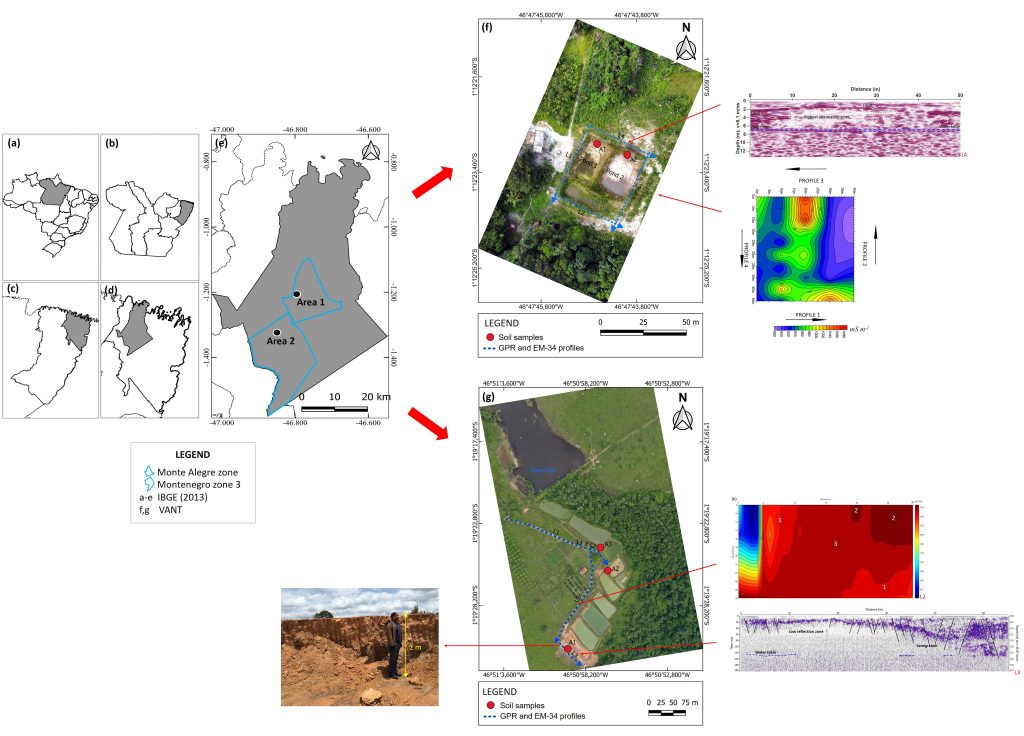
Few Brazilian rural landowners are aware of the technology available to survey the subsoil of terrains earmarked for aquaculture operations. This study evaluated subsoils of Monte Alegre (area 1) and Montenegro 3 (area 2) aquaculture zones in the geographic region of Bragança (Amazon region, northern Brazil), and the adequacy of these areas for aquaculture. Ground Penetrating Radar, electrical conductivity measurements, and sedimentological analyses were applied to evaluate the subsoil of fish farms. Apparent conductivity values recorded by the Electromagnetic Induction (EMI) in area 1 indicated possible presence of clayey soils. Excavation analysis and sedimentological samples (sand) from this site confirmed the inadequacy of the terrain. The EMI tool in area 2 indicated possible presence of clayey soils. Geophysical and sedimentological results from the site confirmed its suitability. These geophysical tools are recommended for evaluating prospective aquaculture sites, given their capacity to provide reliable data on the subsoil characteristics , which is essential to guarantee the success and sustainability of aquaculture operations.
171