

Rev. Bras. Ciênc. Solo.2020;44:e0200076.
Sediment source and volume of soil erosion in a gully system using UAV photogrammetry
Bernardo Moreira Cândido ![]() , Mike James
, Mike James ![]() , John Quinton
, John Quinton ![]() , Wellington de Lima
, Wellington de Lima ![]() , Marx Leandro Naves Silva
, Marx Leandro Naves Silva ![]()
11/Nov/2020
DOI: 10.36783/18069657rbcs20200076
Graphical Abstract
Highlights
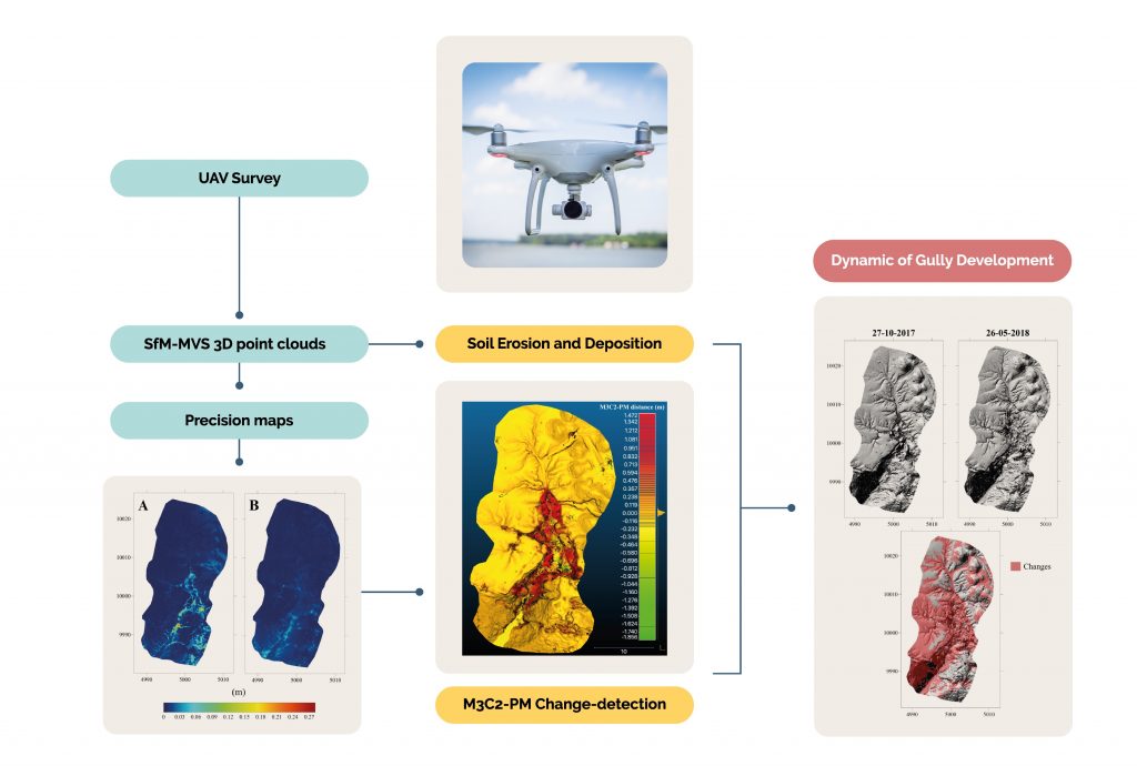
Unmanned Aerial Vehicles can be used to remotely quantify the sediment sources in a gully system with millimetric precision, allowing to evaluate even the contribution of sheet erosion to the gully development.
Structure-from-motion/multiview-stereo photogrammetry can produce erosion maps showing the dynamic of gully development over the time and the spatial distribution of the erosion along the gully system.
Precision maps can be used to estimate the spatial variation of possible error along the area.
Rills and laminar erosion contributed 8 and 3 %, respectively, to the total sediment yield, while the mass movements corresponded with most of the sediment generation in the gully.
Of the total sediment produced in the system, only 24 % was stored in the gully, indicating its high activity and instability.
ABSTRACT
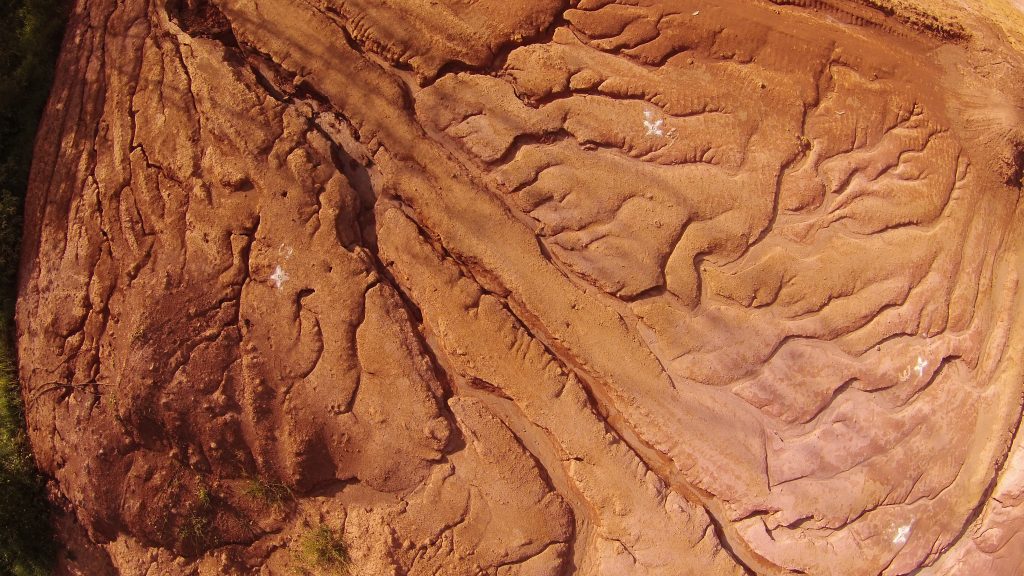
Gully erosion is a severe way of land degradation. Gullies threaten the sustainability of agro-ecosystems, causing quantitative and qualitative reduction of groundwater, farmland productivity, and waterways sedimentation. Since the gully development on the surface begins with water flow and sheet erosion, accurate monitoring of the erosive processes in a gully system and its quantification is key for the development of effective strategies to control soil erosion in gullies. Here, we demonstrate the first use of unmanned aerial vehicle (UAV) and structure-from-motion/multiview-stereo photogrammetry to evaluate the relative contribution of the different types of erosion (sheet, rill, and gully sidewall) in the gully development. A gully located at Lavras, Brazil, was surveyed using a UAV equipped with a RGB camera. The Precision Maps (PM) variant of the Multiscale Model to Model Cloud Compare (M3C2) algorithm was used to calculate spatial changes in the soil surface topography and to quantify the volumes of sediments lost and gained in the gully system. The point clouds showed root mean square errors of order ~ 3 mm on xyz on check points. The spatial variation of precision along the gully ranged from 0.006 to 0.276 m, considering the M3C2-PM uncertainty values. The results revealed that the main source of sediment in the gully studied was due to the mass movement processes. Rills and laminar erosions contributed 8 and 3 %, respectively, to the total sediment yield, while the mass movements corresponded with most of the sediment generation in the gully. Of the total sediment produced in the system, only 24 % was stored in the gully, indicating its high activity and instability. For the first time, the sediment sources of a gully were quantified remotely and with millimetric precision. The UAV photogrammetry generated high-resolution measurements, allowing evaluation of the contribution of sheet erosion in the generation of sediment of the gully. This opens up new possibilities in the studies involving the dynamics of gullies, since the understanding of the spatial and temporal behaviour of the erosive processes are important in the development of control strategies and monitoring of the evolution of a gullies complex.
667
That’s a great paper! For sure, it will open up new possibilities in gully erosion studies. Congratulations to the authors and the Brazilian Journal.
Cheers,
JK