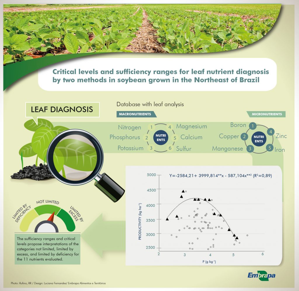
Critical levels and sufficiency ranges for leaf nutrient diagnosis by two methods in soybean grown in the Northeast of Brazil
Henrique Antunes de Souza ![]() , Paulo Fernando de Melo Jorge Vieira
, Paulo Fernando de Melo Jorge Vieira ![]() , Danilo Eduardo Rozane
, Danilo Eduardo Rozane ![]() , Edvaldo Sagrilo
, Edvaldo Sagrilo ![]() , Luiz Fernando Carvalho Leite
, Luiz Fernando Carvalho Leite ![]() , Ane Caroline Melo Ferreira
, Ane Caroline Melo Ferreira ![]()
20/Jul/2020
ABSTRACT Establishing sufficiency ranges and critical levels of nutrients are important for a correct evaluation of plant nutrition through leaf diagnosis. This study aimed to propose critical levels and sufficiency ranges of macro and micronutrients based on leaf diagnosis of soybean plants. The database used was generated from 86 samples of the third trifoliate leaf without petiole, collected during the flowering stage from soybean plants of the main cultivars used in the states of Piauí and Maranhão, Northeast region of […]
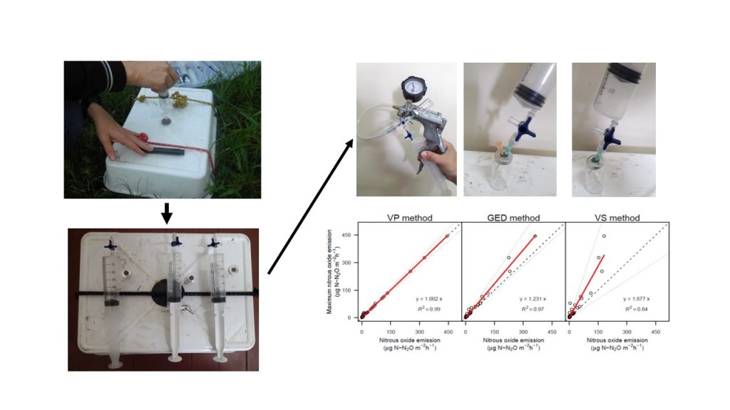
Comparison of field measurement methods of nitrous oxide soil emissions: from the chamber to the vial
Vanina Rosa Noemí Cosentino ![]() , Romina Ingrid Romaniuk
, Romina Ingrid Romaniuk ![]() , Ana María Lupi
, Ana María Lupi ![]() , Federico Manuel Gómez
, Federico Manuel Gómez ![]() , Helena Rimski Korsakov
, Helena Rimski Korsakov ![]() , Carina Rosa Álvarez
, Carina Rosa Álvarez ![]() , [...]
, [...]
16/Jul/2020
ABSTRACT Nitrous oxide (N2O) is a greenhouse gas that contributes substantially to global climate change. The N2O soil emissions have a large uncertainty because of its low atmospheric concentration levels and enormous spatial and temporal variability, which hinders its correct field measurement. For this reason, there are many papers focused on improving the N2O measurements in the field, which focus on different parts of the measurement process. However, no studies have focused on determining the appropriate method, in terms of […]
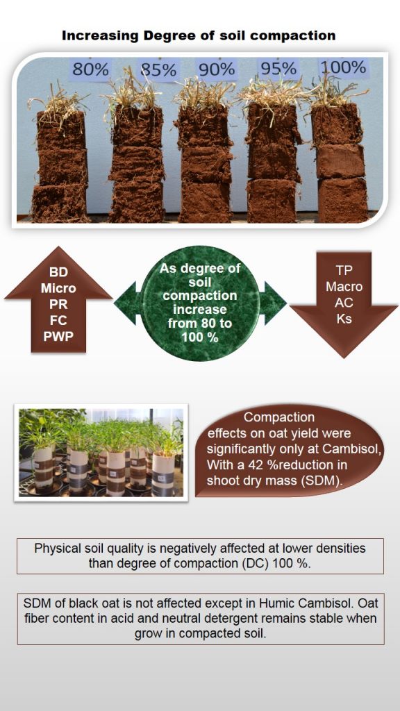
Soil compaction effect on black oat yield in Santa Catarina, Brazil
Jadiel Andognini ![]() , Jackson Adriano Albuquerque
, Jackson Adriano Albuquerque ![]() , Maria Izabel Warmling
, Maria Izabel Warmling ![]() , Juliano Silva Teles
, Juliano Silva Teles ![]() , Gisele Barbosa da Silva
, Gisele Barbosa da Silva ![]()
16/Jul/2020
ABSTRACT Cultivated soils, when submitted to agricultural practices, tend to compact due to the pressure exerted by agricultural machines and implements, a process that compromises soil quality and system sustainability. Specific properties of each soil, such as particle size and organic matter content, interfere with the process and degree of compaction and, consequently, plant growth. This study aimed to analyze the effect of different degrees of compaction (DC) on soil physical properties and black oat (Avena strigosa Schreb) growth. For […]
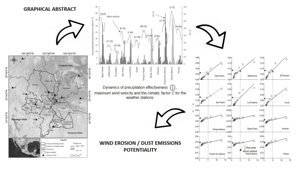
Potential of wind erosion and dust emission in an arid zone of northern Mexico: A simple assessment method
Maritza Argelia Macias-Corral ![]() , Gerardo Esquivel-Arriaga
, Gerardo Esquivel-Arriaga ![]() , Ignacio Sanchez-Cohen
, Ignacio Sanchez-Cohen ![]()
16/Jul/2020
ABSTRACT Wind erosion is the main problem that arid lands in northern Mexico are facing. Quantification of this phenomenon is crucial for planning purposes and to scale its impact. The challenge is to assess the problem under limited availability of climatic information. This study aimed to identify potential areas of dust emissions in an arid zone of Northern Mexico. Wind direction and intensity were characterized through a robust index that involves rainfall and evaporation as well as the climatic factor […]
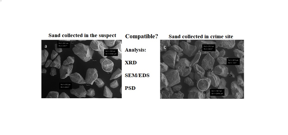
Sand fraction is not suitable for forensic investigations in subtropical soils
Vander Freitas Melo ![]() , Samara Alves Testoni
, Samara Alves Testoni ![]() , Lorna Anne Dawson
, Lorna Anne Dawson ![]() , Fábio Augusto da Silva Salvador
, Fábio Augusto da Silva Salvador ![]()
16/Jul/2020
ABSTRACT Most of the forensic comparison of soils has focused on the clay and silt fractions at the expense of the coarser particles. This study aimed to test the potential of elemental and physical analyses in the sand fraction from subtropical soils to discriminate samples collected in areas under different parent material (claystone and marble) and in areas with the same parent material at a simulated crime scene. Scanning electron microscopy coupled to an energy dispersive X-ray spectrometer (SEM-EDS) analysis […]
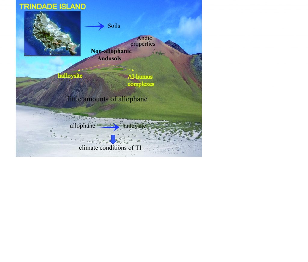
Non-allophanic Andosols of Trindade Island, south Atlantic: a new soil order in Brazil
Ana Carolina Campos Mateus ![]() , Angélica Fortes Drummond Chicarino Varajão
, Angélica Fortes Drummond Chicarino Varajão ![]() , Fábio Soares de Oliveira
, Fábio Soares de Oliveira ![]() , Sabine Petit
, Sabine Petit ![]() , Carlos Ernesto Gonçalves Reynaud Schaefer
, Carlos Ernesto Gonçalves Reynaud Schaefer ![]()
16/Jul/2020
ABSTRACT The pedological studies carried out so far in Trindade Island (TI) have obtained patchy evidences of allophane, without detailed mineralogical and micromorphological studies to confirm the occurrence of Andosols in TI. Therefore, in this study, the mineralogical, micromorphological, physical and chemical characterization of four soil profiles from Vulcão do Paredão (P1) and Morro Vermelho formations (P2, P3, and P4) were carried on the latest volcanic events in Brazil from Trindade Island (TI) with the aim of to evaluate the […]
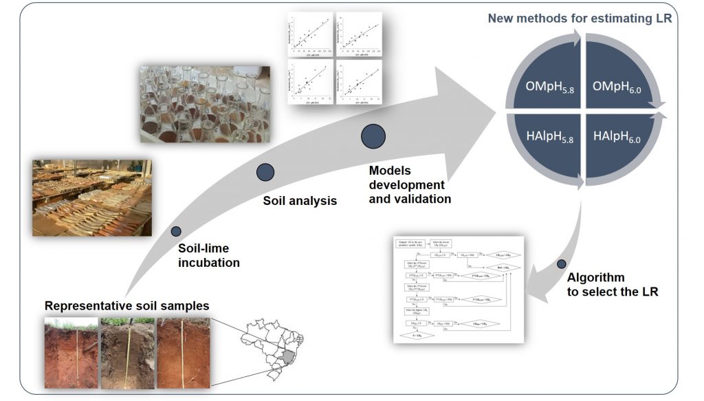
New methods for estimating lime requirement to attain desirable pH values in Brazilian soils
Welldy Gonçalves Teixeira ![]() , V. Víctor Hugo Alvarez
, V. Víctor Hugo Alvarez ![]() , Júlio César Lima Neves
, Júlio César Lima Neves ![]()
03/Jul/2020
ABSTRACT In Brazil, empirical models are traditionally used to determine lime requirement (LR), but their reliability is doubtful in most cases, since they can lead to under- or overestimation of LR for different soil types. In this study, the most critical characteristics influencing LR were selected to develop reliable models for predicting LR that raise soil pH to optimum values for crop production in Brazil. Soil samples (n = 22) with varying proportions of clay (5-88 %) and organic matter […]
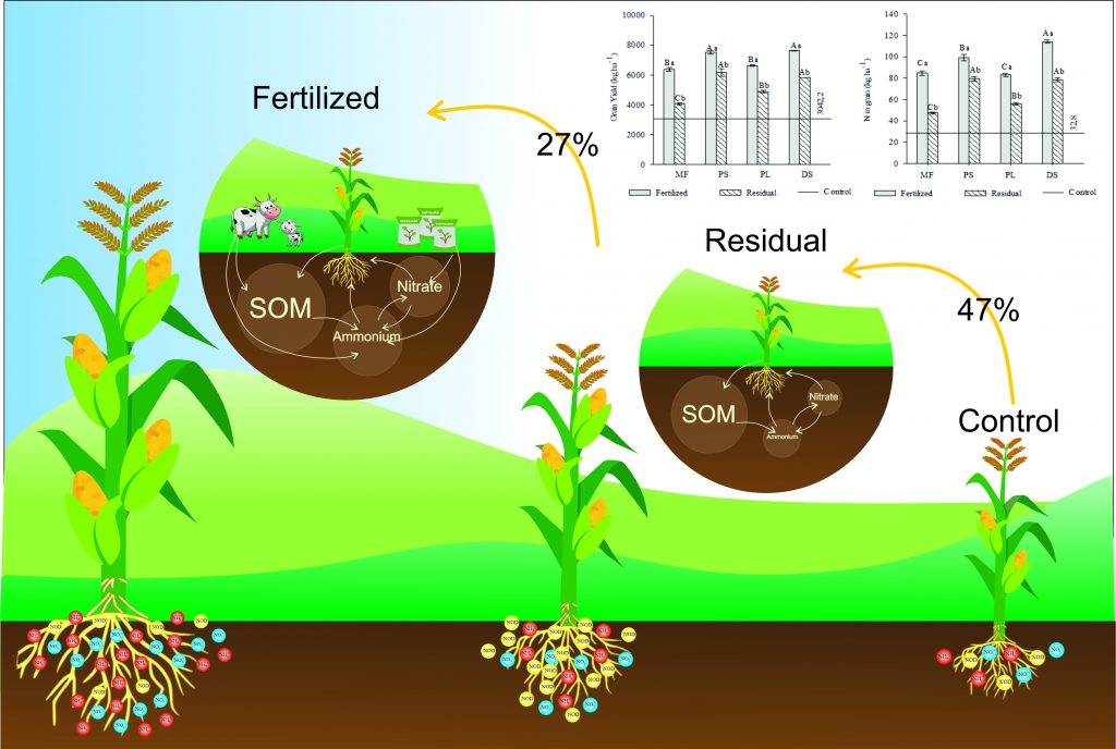
Residual and immediate effect after 16 applications of organic sources on yield and nitrogen use efficiency in black oat and corn
Alessandra Bacca ![]() , Carlos Alberto Ceretta
, Carlos Alberto Ceretta ![]() , Matheus Severo de Souza Kulmann
, Matheus Severo de Souza Kulmann ![]() , Rodrigo Otavio Schneider Souza
, Rodrigo Otavio Schneider Souza ![]() , Paulo Ademar Avelar Ferreira
, Paulo Ademar Avelar Ferreira ![]() , Lucas Antonio Telles Rodrigues
, Lucas Antonio Telles Rodrigues ![]() , [...]
, [...]
29/Jun/2020
ABSTRACT Soils with a long-term history of animal manure application exhibit higher residual effects of nitrogen (N) in soil and can affect the efficiency with which N will be used. This study aimed to evaluate how the immediate and residual effect of 16 applications of animal manure reflects on yields of black oat and corn rotation system, as well as N use efficiency. The study was carried out in no-tillage from 2004 to 2016 in Brazil. The treatments were pig […]
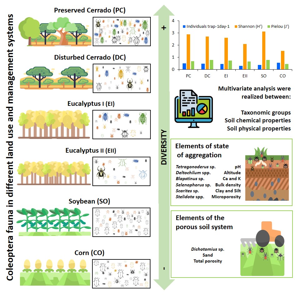
Abundance and diversity of beetles (Insecta: Coleoptera) in land use and management systems
Alana Cristina Cunha Bernardes ![]() , Osmann Cid Conde Oliveira
, Osmann Cid Conde Oliveira ![]() , Raimunda Alves Silva
, Raimunda Alves Silva ![]() , Patrícia Maia Correia Albuquerque
, Patrícia Maia Correia Albuquerque ![]() , José Manuel Macário Rebêlo
, José Manuel Macário Rebêlo ![]() , Jéssica Herzog Viana
, Jéssica Herzog Viana ![]() , [...]
, [...]
19/Jun/2020
ABSTRACT Soil beetles’ communities are responsible for many ecosystem services, and are very sensitive to environmental changes. Thus, this study aimed to evaluate the abundance and diversity of the soil coleoptera fauna under uses and management and also to identify relationships of the beetle community with soil’s physical and chemical properties. The experiment had six experimental plots set up an Oxisol (Latossolo): corn (CO), soybean (SO), 7-year-old eucalyptus (EI), 4-year-old eucalyptus (EII), preserved Cerrado (PC), and disturbed Cerrado (DC). Soil […]
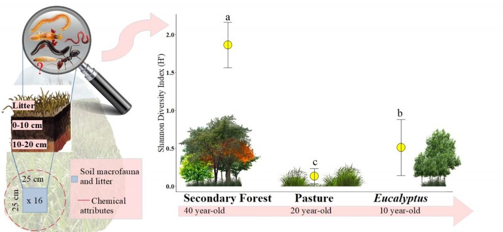
Diversity and abundance of soil macrofauna in three land use systems in eastern Amazonia
Werica Larissa Farias de Vasconcelos ![]() , Diego de Macedo Rodrigues
, Diego de Macedo Rodrigues ![]() , Rafael Oliveira Carvalho Silva
, Rafael Oliveira Carvalho Silva ![]() , Sônia Sena Alfaia
, Sônia Sena Alfaia ![]()
19/Jun/2020
ABSTRACT Given the influence of edaphic macrofauna in the physical, chemical, and biological processes that sustain the organic matter cycle in the soil of tropical ecosystems, this study aimed to evaluate the effect of the sequence: Secondary Forest – Pasture – Eucalyptus monoculture on the macrofauna structure in Southeast of Pará State, Brazil. In each land use system, two 350 m transect were taken. The data was collected in 8 sampling sites, which were 50 m apart in each transect […]