

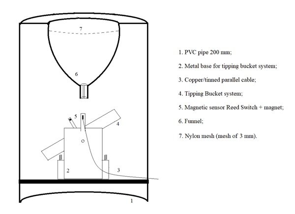
Tipping Bucket Prototype for Automatic Quantification of Surface Runoff Rate in Plots
André Somavilla, Paulo Ivonir Gubiani ![]() , Anderson Luiz Zwirtz
, Anderson Luiz Zwirtz
07/Jan/2019
ABSTRACT: Quantification of runoff rate is an onerous task with non-automated devices; it requires a lot of manual labor to perform measurements. In this study, an automatic device to quantify the surface runoff rate from plots with a small area was developed and tested. The prototype was based on the tipping bucket technique and built with reused materials. Its performance was tested in the laboratory and a calibration curve was developed to improve measurement accuracy. The device can be used […]
Phosphorus Forms in Sediments as Indicators of Anthropic Pressures in an Agricultural Catchment in Southern Brazil
21/Nov/2017
ABSTRACT Phosphorus (P) fractionation is a suitable procedure to ascertain P lability in sediments and is able to distinguish sources of P under different soil management practices in a catchment. Brazil is the second largest producer and the largest exporter of tobacco in the world. Inadequate management of cultivated areas exposes the soil to erosion processes, accelerating the transfer of sediment and P to water bodies, which leads to eutrophication. We evaluated the P forms in suspended sediments collected at […]
Soil loss minimization as a function of forest size and location in a “water conservation program”
01/Dec/2011
As conflicts related to the water use in Brazil are increasing, the implementation of policies that can mitigate these problems has become crucial. In this context, the concept of Payment for Environmental Services (PES) has been widely accepted and applied around the world and also in Brazil. The municipality of Extrema, in the State of Minas Gerais, was the first in Brazil to implement a PES program, known as “Conservador das Águas”. This study aimed to evaluate soil losses in […]
Fitting methods and semi-variogram models applied to the study of spatial variability of physical-hydric soil attributes
01/Jun/2007
The spatial variability and spatial dependence structure of physical water soil attributes (total porosity – VTP, saturated hydraulic conductivity – k0, drainable porosity – DP and soil moisture at field capacity – qcc) was evaluated for an Oxisol representative of Ribeirão Marcela watershed, in the Alto Rio Grande domain. Spherical and exponential semi-variograms were fitted by the weighted minimum square (WMS) and maximum likelihood (ML) methodologies. Undisturbed and disturbed physical water samples were collected from the 0-0.15 m layer for […]
Application of a comparative index in evaluation of land degradation risk
01/Dec/1998
The determination of land degradation risk in a watershed is an important factor in environmental and agricultural land-use planning. The current trend is to analyze the necessary information for land evaluation in a less subjective way and compatible with geoprocessing techniques. However, criteria and parameters used to quantitatively evaluate the land degradation risk at the watershed scale and based on Geographic Information Systems (GIS) still need to be better defined. The objective of this study, conducted in the second semester […]