

Optimized data-driven pipeline for digital mapping of quantitative and categorical properties of soils in Colombia
Alejandro Coca-Castro ![]() , Joan Sebastián Gutierrez-Díaz
, Joan Sebastián Gutierrez-Díaz ![]() , Victoria Camacho
, Victoria Camacho ![]() , Andrés Felipe López
, Andrés Felipe López ![]() , Patricia Escudero
, Patricia Escudero ![]() , Pedro Karin Serrato
, Pedro Karin Serrato ![]() , [...]
, [...]
24/Nov/2021
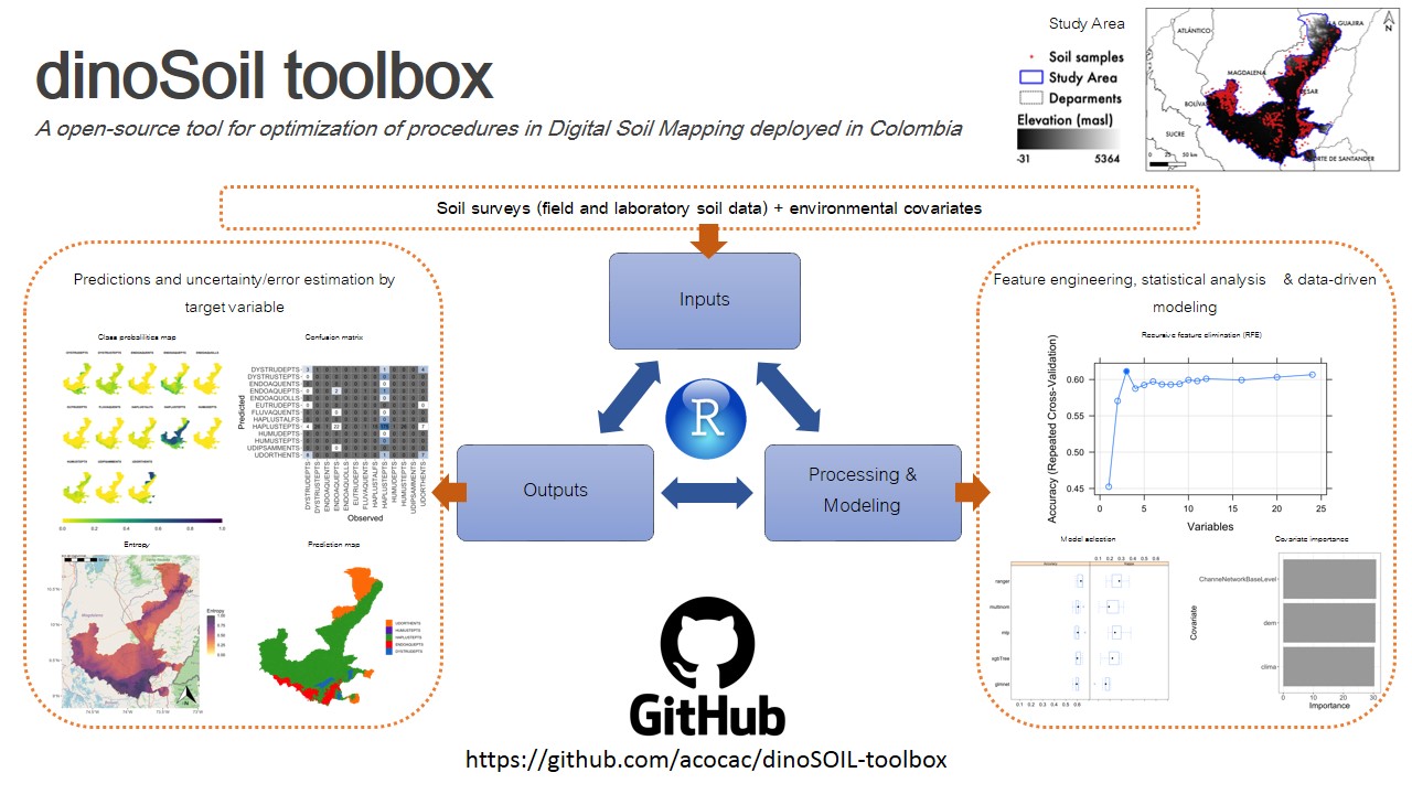
ABSTRACT Soil maps provide a method for graphically communicating what is known about the spatial distribution of soil properties in nature. We proposed an optimized pipeline, named dino-soil toolbox, programmed in the R software for mapping quantitative and categorical properties of legacy soil data. The pipeline, composed of four main modules (data preprocessing, covariates selection, exploratory data analysis and modeling), was tested across a study area of 14,537 km 2 located between the departments of Cesar and Magdalena, Colombia. We […]
Numerical modeling of the effect of variation of boundary conditions on vadose zone hydraulic properties
01/Feb/2011
An accurate estimation of hydraulic fluxes in the vadose zone is essential for the prediction of water, nutrient and contaminant transport in natural systems. The objective of this study was to simulate the effect of variation of boundary conditions on the estimation of hydraulic properties (i.e. water content, effective unsaturated hydraulic conductivity and hydraulic flux) in a one-dimensional unsaturated flow model domain. Unsaturated one-dimensional vertical water flow was simulated in a pure phase clay loam profile and in clay loam […]
Uncertainty in erosion prediction with usle: impacts and mitigation
01/Dec/2010
Despite the significance uncertainty in the variables of erosion prediction models, spatial and temporal variability is seldom considered in soil conservation analyses and planning. The consequences of this simplification are misleading soil loss predictions, with consequences for the agricultural and environmental sustainability of agricultural fields. The objective of this paper was (a) to estimate the effect of spatial and temporal variability of the USLE factors on erosion prediction of a homogeneous agricultural field, in the Distrito Federal (Brazil), (b) to […]