

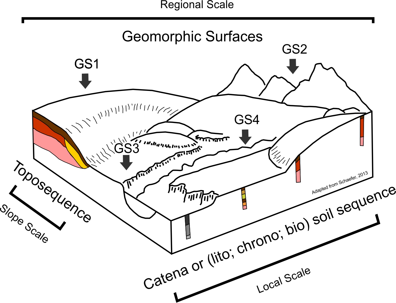
Toposequence: What are we talking about?
Grace Bungenstab Alves ![]() , Fábio Soares de Oliveira
, Fábio Soares de Oliveira ![]() , Artur Henrique Nascimento da Silva
, Artur Henrique Nascimento da Silva ![]() , Valdomiro Severino de Souza Junior
, Valdomiro Severino de Souza Junior ![]()
10/Jun/2024
ABSTRACT The term toposequence, proposed to designate a lateral succession of soils on a slope due to the influence of topography, began to be used differently over time, distancing itself from its original concept. Here, we discuss how this concept has been used since its inception. We carried out bibliometric analyses of publications in the database available on the Web of Science since 1900. Three main approaches and related concepts, explicit or not, one at a regional scale and two […]
The combined use of reflectance, emissivity and elevation Aster/Terra data for tropical soil studies
01/Dec/2009
Reflectance, emissivity and elevation data of the sensor ASTER (Advanced Spaceborne Thermal Emission and Reflection Radiometer)/Terra were used to characterize soil composition variations according to the toposequence position. Normalized data of SWIR (shortwave infrared) reflectance and TIR (thermal infrared) emissivity, coupled to a soil-fraction image from a spectral mixture model, were evaluated to separate bare soils from nonphotosynthetic vegetation. Regression relationships of some soil properties with reflectance and emissivity data were then applied on the exposed soil pixels. The resulting […]
Multiple logistic regression applied to soil survey in rio grande do sul state, Brazil
01/Dec/2008
Logistic nominal regressions establish mathematical relations between continuous or discrete independent variables and discrete dependent variables. The prediction potential of the occurrence and distribution of soil classes in the region Ibirubá and Quinze de Novembro, RS, Brazil was evaluated. Using a digital elevation model (DEM) with 90 m resolution, were calculated several topographic characteristics (elevation, slope, and curvature) and hydrographic variables (distance to rivers, flow length, topographical wetness index, and stream power index). Multiple logistic regressions were established between the […]