

Soil legacy data: An opportunity for digital soil mapping
Beatriz Macêdo Medeiros ![]() , Letícia Sequinatto Rossi
, Letícia Sequinatto Rossi ![]() , Alexandre ten Caten
, Alexandre ten Caten ![]() , Gustavo Eduardo Pereira
, Gustavo Eduardo Pereira ![]() , Elisângela Benedet da Silva
, Elisângela Benedet da Silva ![]() , Kelly Tamires Urbano Daboit
, Kelly Tamires Urbano Daboit ![]()
23/Jul/2024
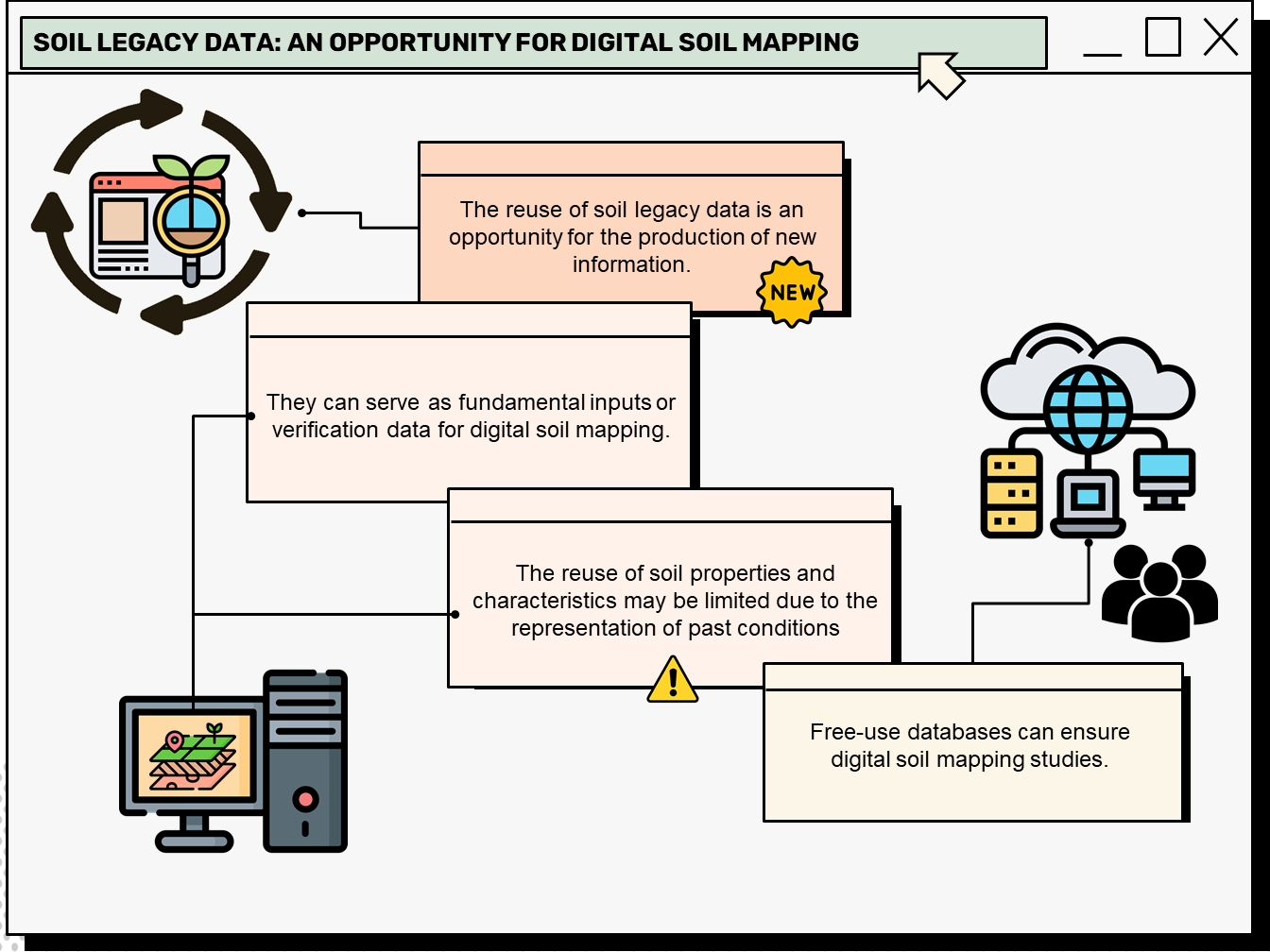
ABSTRACT Soil legacy data is past information on soils available from various sources (e.g. survey reports and maps). When compiled and organized, data obtained through historical retrieval can be used as basic input or validation data for digital soil mapping. A bibliometric analysis of this topic can reveal research patterns, evolution, and scientific contribution, thus mapping the science produced in a specific period and determining the trend in research topics based on search terms. This article presents the characterization of […]
Disposal of solid waste from civil construction: a screening proposal for a suitability system and case study in Nepomuceno, Minas Gerais
Luana Sousa Costa ![]() , Marcelo Henrique Procópio Pelegrino
, Marcelo Henrique Procópio Pelegrino ![]() , Bruno Silva Villela
, Bruno Silva Villela ![]() , Maria Eduarda Carvalho Monteiro
, Maria Eduarda Carvalho Monteiro ![]() , Raísa Brito Vilela
, Raísa Brito Vilela ![]() , Daniela de Fátima Pedroso
, Daniela de Fátima Pedroso ![]() , [...]
, [...]
11/Mar/2024
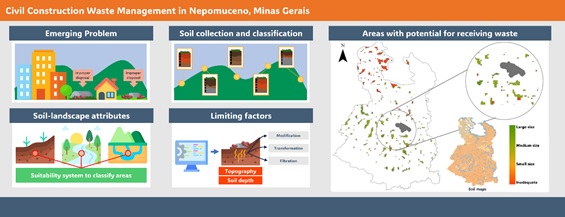
ABSTRACT Most Brazilian municipalities do not have regulated areas for solid waste disposal in civil construction. Usually, residues are disposed of vacant lots and dumps, posing risks to the population health and the environment. Soils are the primary means for the disposal or recycling of waste, highlighting the importance of well-characterized soils and their respective landscape. This study aimed to establish a land suitability system for solid residues in civil construction and apply such information in a case study in […]
Digital soil mapping for the Parnaíba River delta, Brazilian semiarid region
João Victor Alves Amorim ![]() , Gustavo Souza Valladares
, Gustavo Souza Valladares ![]() , Marcos Gervasio Pereira
, Marcos Gervasio Pereira ![]() , Mirya Grazielle Torres Portela
, Mirya Grazielle Torres Portela ![]() , Andréa Maciel Lima
, Andréa Maciel Lima ![]()
04/Apr/2023
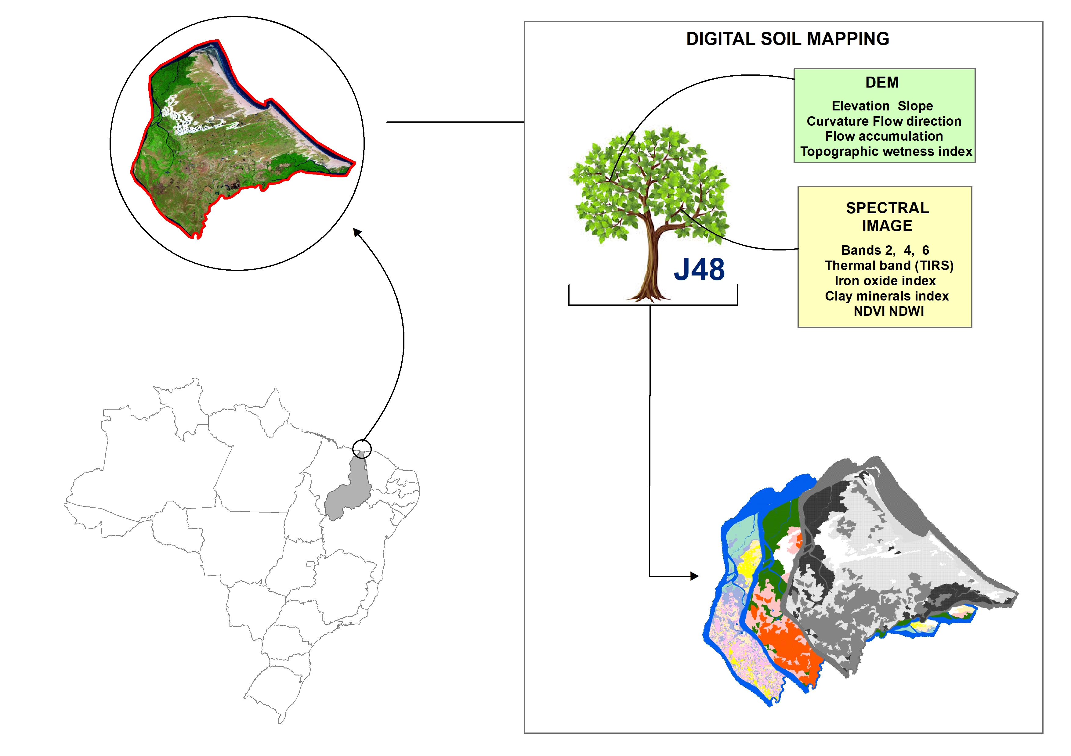
ABSTRACT Soil mapping is a permanent demand, but the traditional method does not allow fast execution and low cost. Digital soil mapping (DSM) aims to improve the process by working with models that treat soil spatial variability quantitatively. In this perspective, the objective of the study is to perform DSM of the Parnaíba River Delta, Northeastern Brazil, through the decision tree (DT) integration technique using a set of attributes derived from the digital elevation model (DEM) and satellite images as […]
How is the learning process of digital soil mapping in a diverse group of land use planners?
Ricardo Simão Diniz Dalmolin, Jean Michel Moura-Bueno, Alessandro Samuel-Rosa ![]() , Carlos Alberto Flores
, Carlos Alberto Flores ![]()
03/Feb/2020
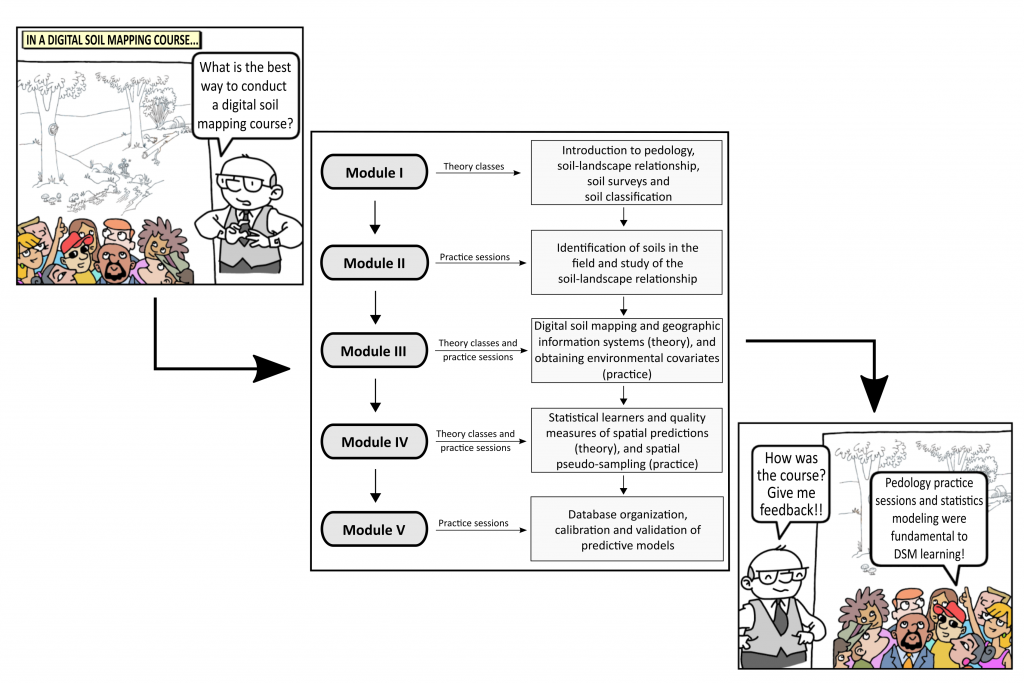
ABSTRACT The use of new technologies, the development of new software, and the advances in the machines ability to process data have brought a new perspective to soil science and especially to pedology, with the advent of digital soil mapping (DSM). To meet the demand for soil surveys in Brazil, it will be necessary to popularize the techniques used in DSM. To identify and map the soil to generate maps of land use capability, we proposed a theoretical and practical […]
Mapping Soil Cation Exchange Capacity in a Semiarid Region through Predictive Models and Covariates from Remote Sensing Data
15/Oct/2018
ABSTRACT: Planning sustainable use of land resources requires reliable information about spatial distribution of soil physical and chemical properties related to environmental processes and ecosystemic functions. In this context, cation exchange capacity (CEC) is a fundamental soil quality indicator; however, it takes money and time to obtain this data. Although many studies have been conducted to spatially quantify soil properties on various scales and in different environments, not much is known about interactions between soil properties and environmental covariates in […]
Multinomial Logistic Regression and Random Forest Classifiers in Digital Mapping of Soil Classes in Western Haiti
18/Jun/2018
ABSTRACT Digital soil mapping (DSM) has been increasingly used to provide quick and accurate spatial information to support decision-makers in agricultural and environmental planning programs. In this study, we used a DSM approach to map soils in western Haiti and compare the performance of the Multinomial Logistic Regression (MLR) with Random Forest (RF) to classify the soils. The study area of 4,300 km2 is mostly composed of diverse limestone rocks, alluvial deposits, and, to a lesser extent, basalt. A soil […]
Conditioned latin hypercube method for soil sampling in the presence of environmental covariates for digital soil mapping
01/Apr/2014
Soil sampling is one of the most important stages in soil surveys. However, in conventional soil surveys, sampling schemes have proven to be inadequate for digital soil mapping because they may affect the results obtained and, in addition, they do not allow statistical estimations to be performed. This study attempts to evaluate the conditioned Latin Hypercube Sampling (cLHS) method with four environmental covariates (elevation, slope, curvature and land cover/land use map), in comparison to random sampling, in allocating 100 sample […]
An appropriate data set size for digital soil mapping in Erechim, Rio Grande do Sul, Brazil
01/Apr/2013
Digital information generates the possibility of a high degree of redundancy in the data available for fitting predictive models used for Digital Soil Mapping (DSM). Among these models, the Decision Tree (DT) technique has been increasingly applied due to its capacity of dealing with large datasets. The purpose of this study was to evaluate the impact of the data volume used to generate the DT models on the quality of soil maps. An area of 889.33 km² was chosen in […]
Soil organic carbon profiles in the South and Southern Espinhaço Mountain Regions, Minas Gerais: modelling of deeper layers
01/Nov/2012
Despite the interest in the spatial variability of key soil properties, depth-related variations have only recently received more attention in the literature. Of all soil properties, soil organic carbon (SOC) is perhaps the most depth-related and difficult to understand. Soil data from two regions in the State of Minas Gerais, Brazil, were used to model SOC profiles and identify factors of influence. In both the South and Southern Espinhaço regions, SOC profiles were best described by log functions. Oxisols had […]
Digital soil mapping: strategy for data pre-processing
01/Aug/2012
The region of greatest variability on soil maps is along the edge of their polygons, causing disagreement among pedologists about the appropriate description of soil classes at these locations. The objective of this work was to propose a strategy for data pre-processing applied to digital soil mapping (DSM). Soil polygons on a training map were shrunk by 100 and 160 m. This strategy prevented the use of covariates located near the edge of the soil classes for the Decision Tree […]