

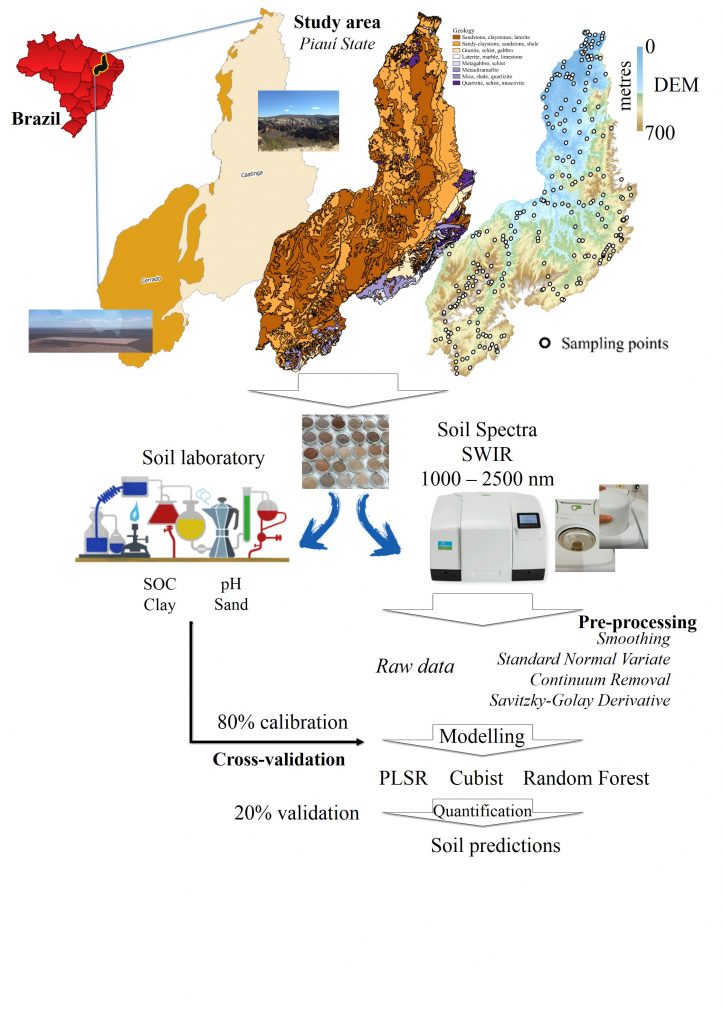
Soil spectral library of Piauí State using machine learning for laboratory analysis in Northeastern Brazil
Wanderson de Sousa Mendes ![]() , Cácio Luiz Boechat
, Cácio Luiz Boechat ![]() , Adriano Venicius Santana Gualberto
, Adriano Venicius Santana Gualberto ![]() , Ronny Sobreira Barbosa
, Ronny Sobreira Barbosa ![]() , Yuri Jacques Agra Bezerra da Silva
, Yuri Jacques Agra Bezerra da Silva ![]() , Paloma Cunha Saraiva
, Paloma Cunha Saraiva ![]() , [...]
, [...]
10/Mar/2021
ABSTRACT Soil chemical and physical analyses are the major sources of data for agriculture. However, traditional soil analyses are time-consuming, not cost-efficient, and not environmentally friendly. An alternative to traditional soil analyses is soil spectroscopy. This technique is a low-cost and quick analytical method, which can be implemented in a laboratory and/or in-situ. Nevertheless, some spectrometers are expensive and do not contemplate the entire spectrum. Despite this limitation, the main objective of the study was to create a soil spectral […]
Surface Spectroscopy of Oxisols, Entisols and Inceptisol and Relationships with Selected Soil Properties
19/Jan/2018
ABSTRACT: Traditional method of soil survey is expensive, slow, and must be carried out by experienced researchers. Thus, advances in soil observation technologies and the need to obtain information quickly by modern techniques have intensified the use of proximal sensing. This study characterized surface reflectance spectra (A horizon) and related them to traditional soil classification, based on morphological, physical, and chemical properties of representative pedogenetic profiles, developed in two toposequences of the Distrito Federal, Brazil. In the toposequences, 15 soil […]
Soil Vis-NIR Spectra and Fuzzy K-means on Definition of Soil Mapping Units in Topossequences
01/Dec/2015
ABSTRACT Knowledge of soils is increasingly important for their correct use in agriculture, in urban growth, and in conservation of natural resources, among other purposes. However, there is a lack of qualified professionals for pedological characterization and mapping, particularly at scales of greater detail. Due to this shortage and due to advances in computational tools and remote sensing, Digital Soil Mapping (DSM) arose in order to assist and expedite pedological survey activities. Thus, the aim of this study was to […]