

Training pedologist for soil mapping: Contextualizing methods and its accuracy using the project pedagogy approach
Elias Mendes Costa ![]() , Marcos Bacis Ceddia
, Marcos Bacis Ceddia ![]() , Felipe Nascimento dos Santos
, Felipe Nascimento dos Santos ![]() , Laiz de Oliveira Silva
, Laiz de Oliveira Silva ![]() , Igor Prata Terra de Rezende
, Igor Prata Terra de Rezende ![]() , Douglath Alves Correa Fernandes
, Douglath Alves Correa Fernandes ![]()
10/Mar/2021
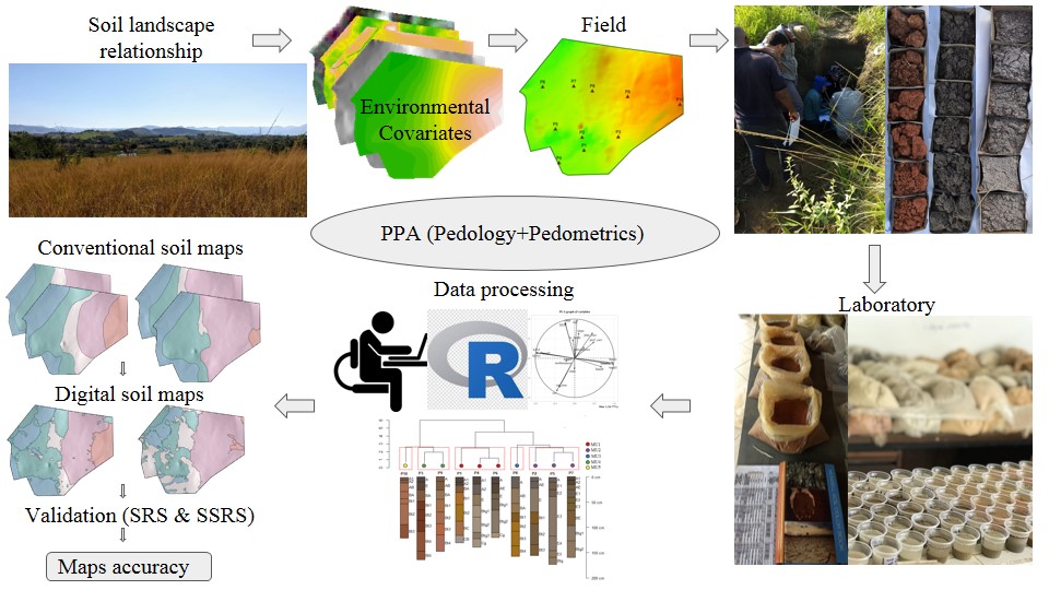
ABSTRACT There is a growing demand for more detailed knowledge about soils, their functions, and connections with human activities and environmental services. In Brazil, where soil survey and mapping have been scarce since the 1990s, there is a remarkable sense of urgency. Recently, a national soil program was created (PronaSolos) to attend to the massive demand for soil information. PronaSolos is an effort to return to the systematic soil mapping of the national territory, which requires many pedologists who master […]
Edaphic and Topographic Factors and their Relationship with Dendrometric Variation of Pinus Taeda L. in a High Altitude Subtropical Climate
26/Nov/2018
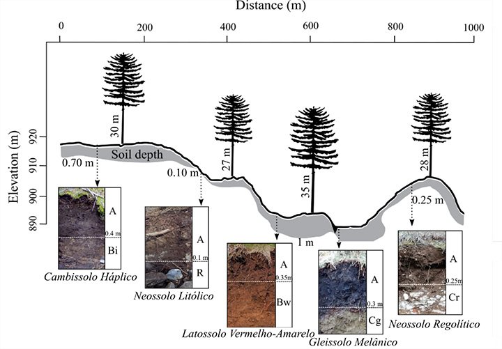
ABSTRACT The study of the relationships between the yield potential of forest stands and the conditions offered for plant development is fundamental for the adequate management of the forest when aiming at sustainable high yields. However, these relations are not clear, especially in commercial forests, on rugged terrain where relationships between the landscape, soil, and plants are more complex. Considering this, we tested the hypothesis that the morphological aspects of the soil conditioned by topography are the main limiting factors […]
Soils Developed on Geomorphic Surfaces in the Mountain Region of the State of Rio de Janeiro
05/Dec/2017
ABSTRACT: The evaluation of soils in representative landscapes constitutes an opportunity to evaluate spatial distribution, discuss formation processes, and apply this knowledge to land use and management. In this sense, from the perspective of an environmentally diversified region, the aim of the present study is to evaluate the occurrence and understand the formation of soils in different geomorphic surfaces of a landscape from a mountain region in the state of Rio de Janeiro. The study was developed in the Pito […]
Comparison between detailed digital and conventional soil maps of an area with complex geology
01/Oct/2013
Since different pedologists will draw different soil maps of a same area, it is important to compare the differences between mapping by specialists and mapping techniques, as for example currently intensively discussed Digital Soil Mapping. Four detailed soil maps (scale 1:10.000) of a 182-ha sugarcane farm in the county of Rafard, São Paulo State, Brazil, were compared. The area has a large variation of soil formation factors. The maps were drawn independently by four soil scientists and compared with a […]
Spatial variability of physical attributes of an alfisol under different hillslope curvatures
01/Jun/2010
The influence of relief forms has been studied by several authors and explains the variability in the soil attributes of a landscape. Soil physical attributes depend on relief forms, and their assessment is important in mechanized agricultural systems, such as of sugarcane. This study aimed to characterize the spatial variability in the physical soil attributes and their relationship to the hillslope curvatures in an Alfisol developed from sandstone and growing sugarcane. Grids of 100 x 100 m were delimited in a convex and […]
Influence of the relief and erosion in the space variability of an oxissol in Jaboticabal, state of São Paulo, Brazil
01/Dec/2003
The aim of this work was to evaluate the relations between landforms and soil erosion of an Oxissol with geostatistical techniques in Jaboticabal (SP), Brazil, in two landform models: concave and linear. Soil samples were collected from both landforms at a depth of 0-20 cm, in a regular 50 x 50 m mesh of seven transects, at totally 412 grid points within an area of 93 ha. Physical and chemical properties were determined at each point and used to estimate the soil erodibility by indirect […]