

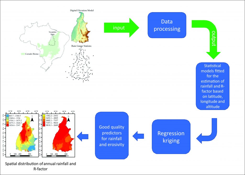
Modeling of the Rainfall and R-Factor for Tocantins State, Brazil
Junior Cesar Avanzi ![]() , Marcelo Ribeiro Viola
, Marcelo Ribeiro Viola ![]() , Carlos Rogério de Mello
, Carlos Rogério de Mello ![]() , Marcos Vinicius Giongo
, Marcos Vinicius Giongo ![]() , Lucas Machado Pontes
, Lucas Machado Pontes ![]()
25/Sep/2019
ABSTRACT The state of Tocantins is inserted in the new Brazilian agricultural frontier and has shown enormous potential for expansion of the agricultural lands. However, there is a lack of more elaborate scientific information for better planning and guide agricultural activities, especially regarding the soil and water conservation. Tocantins has a relevant rainfall spatial variability and, consequently, rainfall erosivity. Thus, this work aimed to develop models to estimate the mean monthly and annual rainfall and means rainfall erosivity factor (R-factor) […]
Spatial Distribution of Annual and Monthly Rainfall Erosivity in the Jaguarí River Basin
30/Oct/2017
ABSTRACT The Jaguarí River Basin forms the main water supply sources for the São Paulo Metropolitan Region and other cities in the state. Since the kinetic energy of rainfall is the driving force of water erosion, the main cause of land and water degradation, we tested the hypothesis of correlation between the erosive potential of rainfall (erosivity) and geographical coordinates and altitude for the purpose of predicting the spatial and temporal distribution of the rainfall erosivity index (EI30) in the […]
Spatial distribution of monthly and annual rainfall and rainfall erosivity in Espirito Santo, Brazil
01/Dec/2012
The mapping of rainfall erosivity and rainfall is a practical and indispensable tool to plan the soil and water management on a regional scale, such as countries, states or basins. The purpose of this study was to analyze the spatial continuity of erosive potential of rainfall and rainfall, considering monthly and annual mean values, and to map them for the State of Espírito Santo, Brazil, providing basic information for the planning of sustainable soil use and management. To this end, […]
Surface runoff in a watershed estimated by dynamic and distributed modeling
01/Feb/2009
Knowledge on the surface runoff in watersheds is very important for a good conservation of natural resources. However, surface runoff is a complex and dynamic process, especially in the context of spatial variability. An application of the Geographical Information System (GIS) tools in small grid cells is therefore adequate. This way, it is possible to consider the spatial behavior of variables associated to the origin of surface runoff. This study aimed to program the Hydrological Models SCS-CN (SCS-Curve Number) and […]
Hydro-physical properties of an Oxisol under different management systems
01/Dec/2007
Chiseling is one of the mechanical practices that can be used in no-tillage (NT) soils in order to reduce soil bulk density, resistance to root penetration, and to increase water permeability. The effect of these changes on plant growth and consequently on grain yield depends on climatic conditions. In soils with ideal moisture conditions, the physical limitations tend to be less noticeable. This study aimed to analyze the changes in the physical and hydric properties of a chiseled Oxisol under […]
Evaluation of a model for estimating the maximum depth of surface runoff
01/Jun/2001
Water erosion is one of the main processes associated to environmental degradation. The soil detachment and transport depends of the raindrop impact and surface runoff. As the agricultural production losses result from water erosion, the correct design of soil conservation systems is necessary to avoid high costs of installation and maintenance. Pruski and collaborators developed a model to estimate the maximum surface runoff depth under typical agricultural conditions. The objective of this study was to evaluate the model developed by […]