Soil carbon prediction in Marajó island wetlands
David Lukas de Arruda ![]() , João Carlos Ker
, João Carlos Ker ![]() , Gustavo Vieira Veloso
, Gustavo Vieira Veloso ![]() , Renata Jordan Henriques
, Renata Jordan Henriques ![]() , Elpídio Inácio Fernandes-Filho
, Elpídio Inácio Fernandes-Filho ![]() , Danilo de Lima Camêlo
, Danilo de Lima Camêlo ![]() , [...]
, [...]
27/Aug/2024
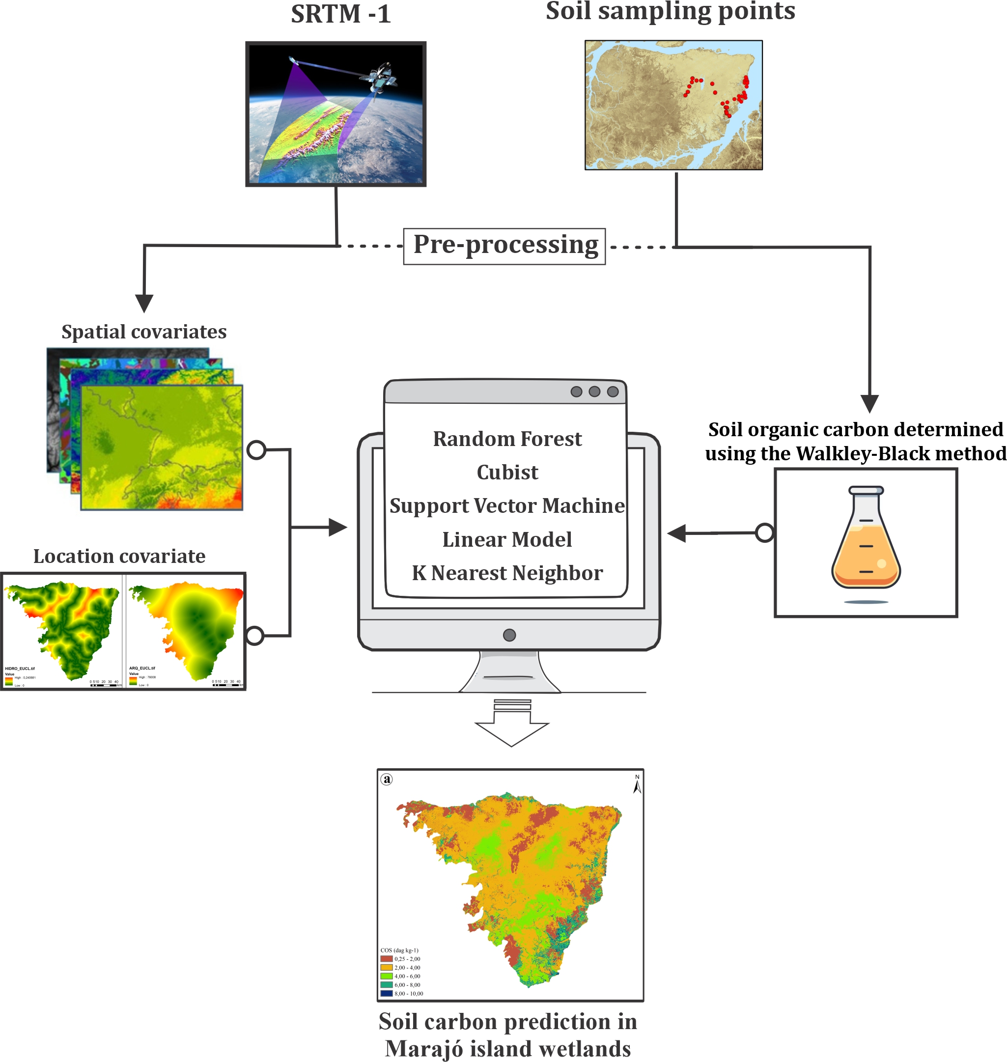
ABSTRACT Soil is an important carbon repository in terrestrial ecosystems, serving a fundamental role in the intricate cycling of this elemental component. Wetlands are crucial components of the global carbon cycle, playing a significant role in carbon sequestration due to their remarkable productivity and unique sedimentary structures. Our study focuses on the wetlands east of Marajó island, recognized as the largest fluvial-marine plain in South America. In this study, we applied a methodological framework to optimize SOC content prediction in […]
Optimized data-driven pipeline for digital mapping of quantitative and categorical properties of soils in Colombia
Alejandro Coca-Castro ![]() , Joan Sebastián Gutierrez-Díaz
, Joan Sebastián Gutierrez-Díaz ![]() , Victoria Camacho
, Victoria Camacho ![]() , Andrés Felipe López
, Andrés Felipe López ![]() , Patricia Escudero
, Patricia Escudero ![]() , Pedro Karin Serrato
, Pedro Karin Serrato ![]() , [...]
, [...]
24/Nov/2021
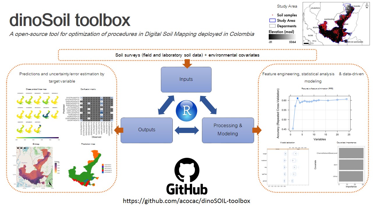
ABSTRACT Soil maps provide a method for graphically communicating what is known about the spatial distribution of soil properties in nature. We proposed an optimized pipeline, named dino-soil toolbox, programmed in the R software for mapping quantitative and categorical properties of legacy soil data. The pipeline, composed of four main modules (data preprocessing, covariates selection, exploratory data analysis and modeling), was tested across a study area of 14,537 km 2 located between the departments of Cesar and Magdalena, Colombia. We […]
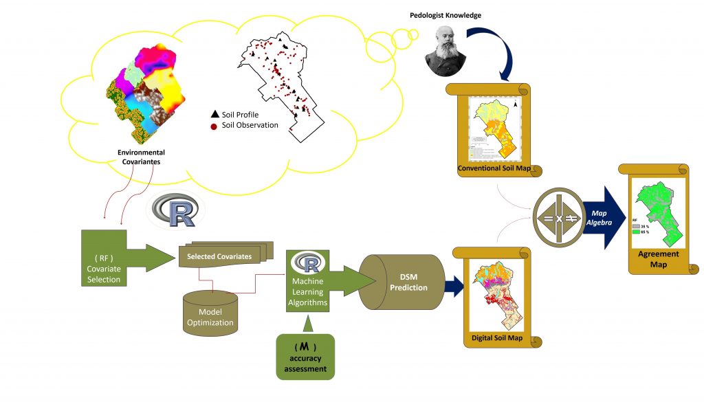
Digital Soil Mapping Using Machine Learning Algorithms in a Tropical Mountainous Area
02/Nov/2018
ABSTRACT: Increasingly, applications of machine learning techniques for digital soil mapping (DSM) are being used for different soil mapping purposes. Considering the variety of models available, it is important to know their performance in relation to soil data and environmental variables involved in soil mapping. This paper investigated the performance of eight machine learning algorithms for soil mapping in a tropical mountainous area of an official rural settlement in the Zona da Mata region in Brazil. Morphometric maps generated from […]