

Hydropedological digital mapping: machine learning applied to spectral VIS-IR and radiometric data dimensionality reduction
Priscilla Azevedo dos Santos ![]() , Helena Saraiva Koenow Pinheiro
, Helena Saraiva Koenow Pinheiro ![]() , Waldir de Carvalho Carvalho
, Waldir de Carvalho Carvalho ![]() , Igor Leite da Silva
, Igor Leite da Silva ![]() , Nilson Rendeiro Pereira
, Nilson Rendeiro Pereira ![]() , Silvio Barge Bhering
, Silvio Barge Bhering ![]() , [...]
, [...]
03/Oct/2023
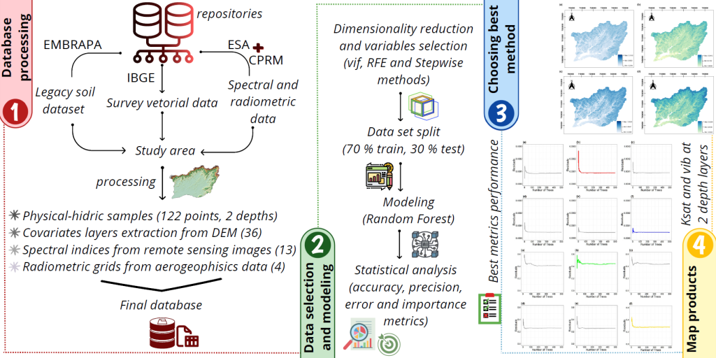
ABSTRACT Pedosphere-hydrosphere interface accounts for the association between soil hydrology and landscape, represented by topographic and Remote Sensing data support and integration. This study aimed to analyze different statistical radiometric and spectral data selection methods and dimensionality reduce environment-related data to support the classification of soil physical-hydric properties, such as soil basic infiltration rate (bir) and saturated hydraulic conductivity (Ksat); as well as to act in data mining processes applied to hydropedological properties digital mapping. Accordingly, research integrated information from […]
Interrill erodibility of different sandy soils increases along a catena in the Caiuá Sandstone Formation
Edivaldo Lopes Thomaz ![]() , Jonez Fidalski
, Jonez Fidalski ![]()
13/Jan/2020
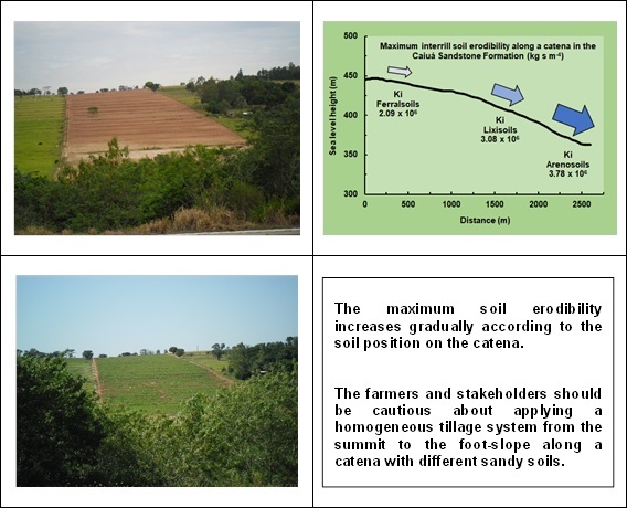
ABSTRACT Soil erosion in tropical areas is a major problem for sustainability in agriculture and soil stability. In the Northwest of Paraná, cassava crop is produced using a conventional tillage system along a catena consisting of different soil classes: Ferralsols (near the summit), Lixisols (mid-slope), and Arenosols (foot-slope). Therefore, differential soil erosion rate and soil degradation are expected along the catena. Here, we test the erodibility of the three sandy soil classes in a representative catena of the Caiuá Sandstone […]
Rill erosion on an oxisol influenced by a thin compacted layer
01/Oct/2013
The presence of compacted layers in soils can induce subprocesses (e.g., discontinuity of water flow) and induces soil erosion and rill development. This study assesses how rill erosion in Oxisols is affected by a plow pan. The study shows that changes in hydraulic properties occur when the topsoil is eroded because the compacted layer lies close below the surface. The hydraulic properties that induce sediment transport and rill formation (i.e., hydraulic thresholds at which these processes occur) are not the […]