
Toposequence: What are we talking about?
Grace Bungenstab Alves ![]() , Fábio Soares de Oliveira
, Fábio Soares de Oliveira ![]() , Artur Henrique Nascimento da Silva
, Artur Henrique Nascimento da Silva ![]() , Valdomiro Severino de Souza Junior
, Valdomiro Severino de Souza Junior ![]()
10/Jun/2024
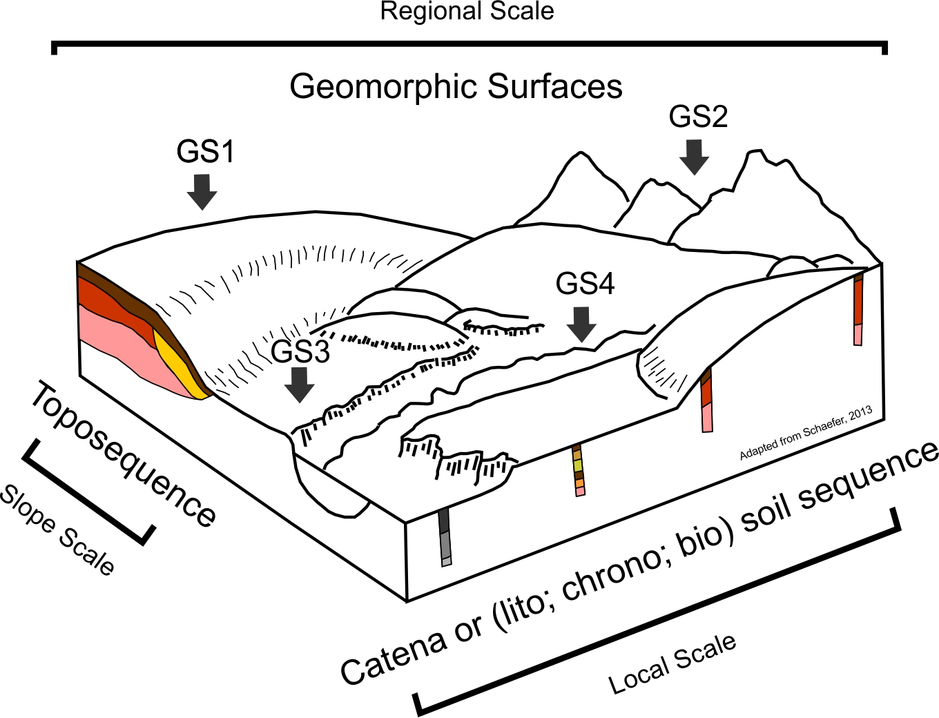
ABSTRACT The term toposequence, proposed to designate a lateral succession of soils on a slope due to the influence of topography, began to be used differently over time, distancing itself from its original concept. Here, we discuss how this concept has been used since its inception. We carried out bibliometric analyses of publications in the database available on the Web of Science since 1900. Three main approaches and related concepts, explicit or not, one at a regional scale and two […]
MATHEMATICAL TOOLS ASSOCIATED WITH MAGNETIC SUSCEPTIBILITY AND LANDSCAPE MODELS IN IDENTIFYING AREAS FOR SPECIFIC MANAGEMENT PRACTICES
01/Jul/2015
The identification of variability patterns through soil properties allows land use and occupation in a sustainable manner. The aim of this study was to ascertain the potential of magnetic susceptibility of the soil and landscape models in defining areas for specific management practices through the use of mathematical tools. The study area is in the municipality of Guariba, SP, Brazil. We chose an area of 110 ha in which three geomorphic surfaces (I, II, and III) had been identified and […]
Soil-landscape relationships in a sandstone-basalt lithosequence in Pereira Barreto, São Paulo
01/Jun/2007
The focus of our study were to study soil-landscape relationships in a sandstone-basalt transition lithosequence and to compare the limits of geomorphic surfaces mapped in the field with those mapped by geostatistical techniques. An area of 530 ha was mapped using GPS equipment in order to generate a model of digital elevation, which allowed for the establishment of a transection of 2.100 m from the hill top downwards. Along the transection, the altitude was measured at 50 m regular intervals […]