

Training pedologist for soil mapping: Contextualizing methods and its accuracy using the project pedagogy approach
Elias Mendes Costa ![]() , Marcos Bacis Ceddia
, Marcos Bacis Ceddia ![]() , Felipe Nascimento dos Santos
, Felipe Nascimento dos Santos ![]() , Laiz de Oliveira Silva
, Laiz de Oliveira Silva ![]() , Igor Prata Terra de Rezende
, Igor Prata Terra de Rezende ![]() , Douglath Alves Correa Fernandes
, Douglath Alves Correa Fernandes ![]()
10/Mar/2021
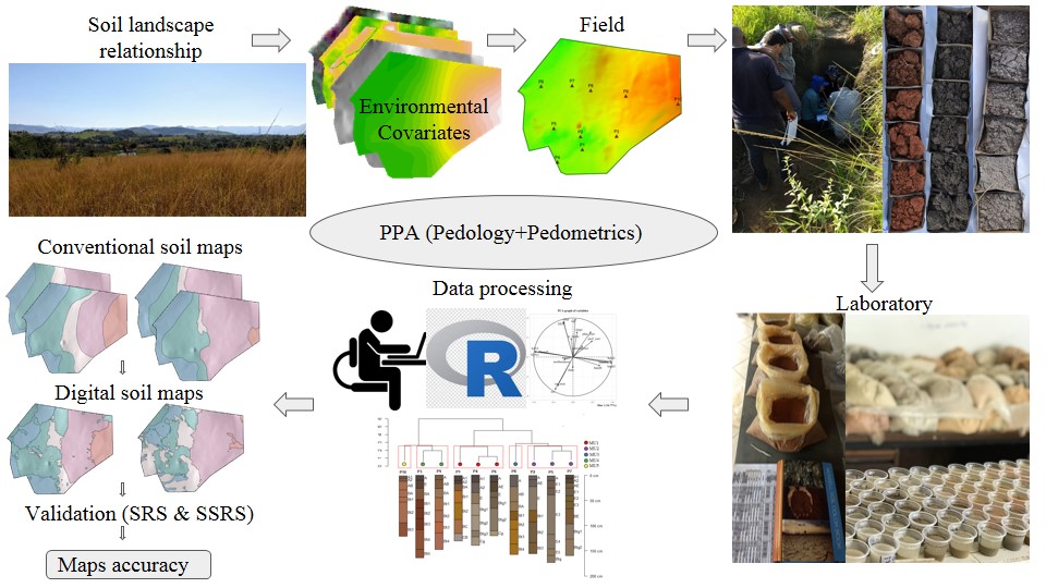
ABSTRACT There is a growing demand for more detailed knowledge about soils, their functions, and connections with human activities and environmental services. In Brazil, where soil survey and mapping have been scarce since the 1990s, there is a remarkable sense of urgency. Recently, a national soil program was created (PronaSolos) to attend to the massive demand for soil information. PronaSolos is an effort to return to the systematic soil mapping of the national territory, which requires many pedologists who master […]
Satellite Spectral Data on the Quantification of Soil Particle Size from Different Geographic Regions
12/Sep/2018
ABSTRACT: The study of soils, including their physical and chemical properties, is essential for agricultural management. Soil quality must be maintained to ensure sustainable production of food and conservation of natural resources. In this context, soil mapping is important to provide spatial information, which can be performed using remote sensing (RS) techniques. Modeling through use of satellite data is uncertain regarding the amplitude of replicability of the models. The aim of this study was to develop a quantification model for […]
Multinomial Logistic Regression and Random Forest Classifiers in Digital Mapping of Soil Classes in Western Haiti
18/Jun/2018
ABSTRACT Digital soil mapping (DSM) has been increasingly used to provide quick and accurate spatial information to support decision-makers in agricultural and environmental planning programs. In this study, we used a DSM approach to map soils in western Haiti and compare the performance of the Multinomial Logistic Regression (MLR) with Random Forest (RF) to classify the soils. The study area of 4,300 km2 is mostly composed of diverse limestone rocks, alluvial deposits, and, to a lesser extent, basalt. A soil […]
Prediction of Topsoil Texture Through Regression Trees and Multiple Linear Regressions
04/Apr/2018
ABSTRACT: Users of soil survey products are mostly interested in understanding how soil properties vary in space and time. The aim of digital soil mapping (DSM) is to represent the spatial variability of soil properties quantitatively to support decision-making. The goal of this study is to evaluate DSM techniques (Regression Trees – RT and Multiple Linear Regressions – MLR) and the ability of these tools to predict mineral fraction content under a wide variability of landscapes. The study site was […]
Spatial Disaggregation of Multi-Component Soil Map Units Using Legacy Data and a Tree-Based Algorithm in Southern Brazil
02/Mar/2018
ABSTRACT Soil surveys often contain multi-component map units comprising two or more soil classes, whose spatial distribution within the map unit is not represented. Digital Soil Mapping tools supported by information from soil surveys make it possible to predict where these classes are located. The aim of this study was to develop a methodology to increase the detail of conventional soil maps by means of spatial disaggregation of multi-component map units and to predict the spatial location of the derived […]
Is It Possible to Classify Topsoil Texture Using a Sensor Located 800 km Away from the Surface?
17/Oct/2016
ABSTRACT It is often difficult for pedologists to “see” topsoils indicating differences in properties such as soil particle size. Satellite images are important for obtaining quick information for large areas. However, mapping extensive areas of bare soil using a single image is difficult since most areas are usually covered by vegetation. Thus, the aim of this study was to develop a strategy to determine bare soil areas by fusing multi-temporal satellite images and classifying them according to soil textures. Three […]
Building predictive models of soil particle-size distribution
01/Apr/2013
Is it possible to build predictive models (PMs) of soil particle-size distribution (psd) in a region with complex geology and a young and unstable land-surface? The main objective of this study was to answer this question. A set of 339 soil samples from a small slope catchment in Southern Brazil was used to build PMs of psd in the surface soil layer. Multiple linear regression models were constructed using terrain attributes (elevation, slope, catchment area, convergence index, and topographic wetness […]
Integration of quickbird data and terrain attributes for digital soil mapping by artificial neural networks
01/Jun/2011
This study evaluated different environmental variables in the digital soil mapping of an area in the northern region of Minas Gerais State, using artificial neural networks. The environmental variables terrain attributes (slope and compound topographic index), the quickbird bands 1, 2 and 3, and lithology were evaluated. The importance of each of the variables in the classification was tested. The “Java Neural Network Simulator” was used with the backpropagation learning algorithm. For each dataset a neural network was created to […]
Multiple Logistic Regressions: controlling factors in applications to soil class prediction
01/Feb/2011
More effective methodologies to determine the soil class distribution must be evaluated in order to meet the demand for soil maps at regional and global scales. In this study, logistic regressions were used as predictive models in an application of Digital Soil Mapping. The models were derived from an existing soil map as dependent variable and terrain attributes as independent variables. The probability of finding soil classes in the landscape at the 1st and 2nd Categorical Level of the Brazilian […]
Multiple logistic regression applied to soil survey in rio grande do sul state, Brazil
01/Dec/2008
Logistic nominal regressions establish mathematical relations between continuous or discrete independent variables and discrete dependent variables. The prediction potential of the occurrence and distribution of soil classes in the region Ibirubá and Quinze de Novembro, RS, Brazil was evaluated. Using a digital elevation model (DEM) with 90 m resolution, were calculated several topographic characteristics (elevation, slope, and curvature) and hydrographic variables (distance to rivers, flow length, topographical wetness index, and stream power index). Multiple logistic regressions were established between the […]