

Assessing Water Erosion Processes in Degraded Area Using Unmanned Aerial Vehicle Imagery
Paulo Siqueira Junior ![]() , Marx Leandro Naves Silva
, Marx Leandro Naves Silva ![]() , Bernardo Moreira Cândido
, Bernardo Moreira Cândido ![]() , Fabio Arnaldo Pomar Avalos
, Fabio Arnaldo Pomar Avalos ![]() , Pedro Velloso Gomes Batista
, Pedro Velloso Gomes Batista ![]() , Nilton Curi
, Nilton Curi ![]() , [...]
, [...]
07/Oct/2019
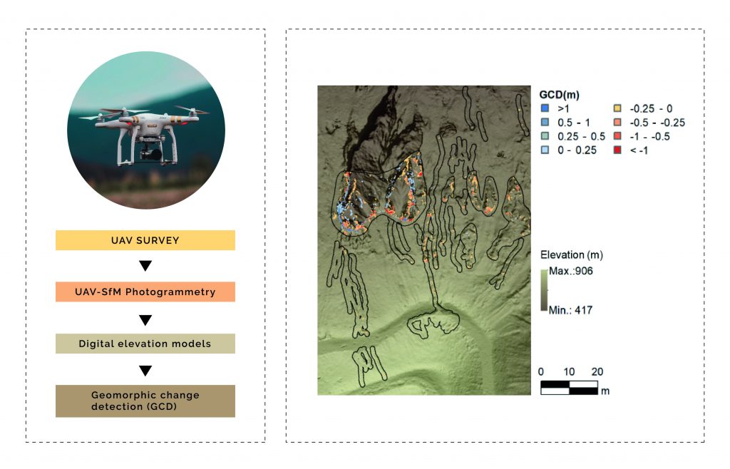
ABSTRACT The use of Unmanned Aerial Vehicles (UAVs) and Structure from Motion (SfM) techniques can contribute to increase the accessibility, accuracy, and resolution of Digital Elevation Models (DEMs) used for soil erosion monitoring. This study aimed to evaluate the use of four DEMs obtained over a year to monitor erosion processes in an erosion-degraded area, with occurrence of rill and gully erosions, and its correlation with accumulated rainfall during the studied period. The DEMs of Geomorphic Change Detection (GCD) of […]
Conditioned latin hypercube method for soil sampling in the presence of environmental covariates for digital soil mapping
01/Apr/2014
Soil sampling is one of the most important stages in soil surveys. However, in conventional soil surveys, sampling schemes have proven to be inadequate for digital soil mapping because they may affect the results obtained and, in addition, they do not allow statistical estimations to be performed. This study attempts to evaluate the conditioned Latin Hypercube Sampling (cLHS) method with four environmental covariates (elevation, slope, curvature and land cover/land use map), in comparison to random sampling, in allocating 100 sample […]
Topographic properties to differentiate Argisols
01/Dec/2013
The topographic conditions controls many hydrological, geomorphological and pedological processes, affectting the solar radiation, pluvial precipitation, superficial water flow, evaporation, soil moisture and vegetation types, among others. Topographic properties derived from a digital elevation model were used to explain the differentiation between soils with an argillic horizon in the region of ”Mar de Morros” in the northwestern State of Rio de Janeiro. Eight soil profiles (four Red Argisols and four Red-Yellow Argisols) developed from noritic granulites, in the municipalities of […]
Computer-assisted cartography using topographic properties: precision and accuracy of local soil maps in central Mexico
01/Jun/2011
Map units directly related to properties of soil-landscape are generated by local soil classes. Therefore to take into consideration the knowledge of farmers is essential to automate the procedure. The aim of this study was to map local soil classes by computer-assisted cartography (CAC), using several combinations of topographic properties produced by GIS (digital elevation model, aspect, slope, and profile curvature). A decision tree was used to find the number of topographic properties required for digital cartography of the local […]
The combined use of reflectance, emissivity and elevation Aster/Terra data for tropical soil studies
01/Dec/2009
Reflectance, emissivity and elevation data of the sensor ASTER (Advanced Spaceborne Thermal Emission and Reflection Radiometer)/Terra were used to characterize soil composition variations according to the toposequence position. Normalized data of SWIR (shortwave infrared) reflectance and TIR (thermal infrared) emissivity, coupled to a soil-fraction image from a spectral mixture model, were evaluated to separate bare soils from nonphotosynthetic vegetation. Regression relationships of some soil properties with reflectance and emissivity data were then applied on the exposed soil pixels. The resulting […]
Use of a geographic information system for a detailed soil survey of the Vale dos vinhedos, RS, Brazil
01/Dec/2008
This study proposes the use of geotechnologies to support detailed soil surveys, from field surveys to the delimitation of mapping units and later the drawing of the final map. The study area corresponds to a topographic map on a scale of 1:5,000 of the Vale dos Vinhedos, in the Serra Gaúcha region, State of Rio Grande do Sul, Brazil. The material used consists of planialtimetric data derived from aerial photographs, navigation GPS (Global Positioning System), and GIS (Geographical Information System) […]
Multiple logistic regression applied to soil survey in rio grande do sul state, Brazil
01/Dec/2008
Logistic nominal regressions establish mathematical relations between continuous or discrete independent variables and discrete dependent variables. The prediction potential of the occurrence and distribution of soil classes in the region Ibirubá and Quinze de Novembro, RS, Brazil was evaluated. Using a digital elevation model (DEM) with 90 m resolution, were calculated several topographic characteristics (elevation, slope, and curvature) and hydrographic variables (distance to rivers, flow length, topographical wetness index, and stream power index). Multiple logistic regressions were established between the […]
Geoprocessing for the characterization of soils developed from basalt and sand material
01/Feb/2008
Brazilian soil surveys are mostly outdated, with few details, usually based on discovery and recognition. This fact can be ascribed to the traditional, slow and expensive soil survey method, requiring a great number of field observations. Thus, faster and cheaper soil mapping techniques must be developed. The objective of this study was to characterize soil mapping units in the region of Ibaté and São Carlos, state of São Paulo, measuring slopes and altitudes, based on a digital elevation model (DEM). […]
Digital terrain analysis: tool for pedoform identification in the “Mar de Morros” watershed (MG)
01/Apr/2005
This study reports on the use of GIS (Geographical Information System) tools for identifying and mapping landform units and soilscapes in a case study of a watershed in the region of Viçosa, Minas Gerais state, based on a topographical base map at a 1:50000 scale. Field work was undertaken to estimate the degree of accuracy of landform units / soilscape identification, obtaining an agreement of 72 % between the automatic and field work classification, and to correlate obtained soilscapes with dominant soil […]