Hydropedological digital mapping: machine learning applied to spectral VIS-IR and radiometric data dimensionality reduction
Priscilla Azevedo dos Santos ![]() , Helena Saraiva Koenow Pinheiro
, Helena Saraiva Koenow Pinheiro ![]() , Waldir de Carvalho Carvalho
, Waldir de Carvalho Carvalho ![]() , Igor Leite da Silva
, Igor Leite da Silva ![]() , Nilson Rendeiro Pereira
, Nilson Rendeiro Pereira ![]() , Silvio Barge Bhering
, Silvio Barge Bhering ![]() , [...]
, [...]
03/Oct/2023
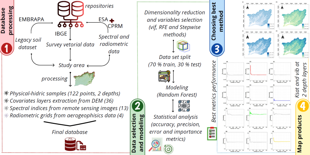
ABSTRACT Pedosphere-hydrosphere interface accounts for the association between soil hydrology and landscape, represented by topographic and Remote Sensing data support and integration. This study aimed to analyze different statistical radiometric and spectral data selection methods and dimensionality reduce environment-related data to support the classification of soil physical-hydric properties, such as soil basic infiltration rate (bir) and saturated hydraulic conductivity (Ksat); as well as to act in data mining processes applied to hydropedological properties digital mapping. Accordingly, research integrated information from […]